world.wikisort.org - Chile
San Antonio is a Chilean port city, commune and the capital of the San Antonio Province in the Valparaíso Region. In the twenty-first century San Antonio has surpassed Valparaíso in freight volume handled, becoming the main freight port of Chile.[4] This has led to the challenging of Valparaíso's traditional moniker Puerto Principal ("Main Port" of Chile).[5] San Antonio is the hub of the fishing area that spans the Chilean coast from Rocas de Santo Domingo to Cartagena.
San Antonio | |
|---|---|
City and Commune | |
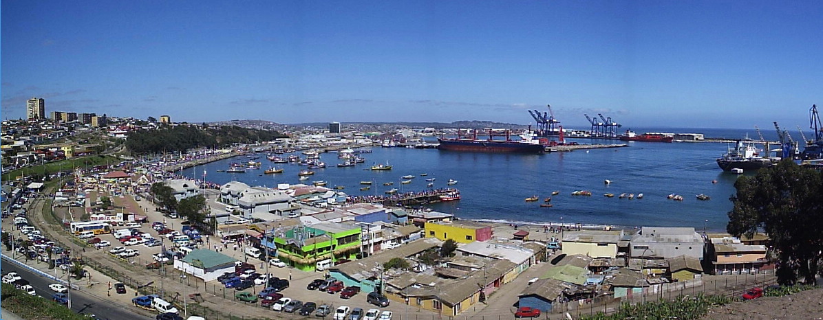 Panorama of the port of San Antonio, before the construction of a mall which obstructed the view of the port. | |
|
 Coat of arms  San Antonio Location in Chile | |
| Nickname: Principal Port (Puerto Principal) | |
| Coordinates (city): 33°35′36″S 71°37′18″W | |
| Country | Chile |
| Region | Valparaíso |
| Province | San Antonio |
| Founded | 1894 |
| Government | |
| • Type | Municipality |
| • Alcalde | Omar Vera (2004-2008) |
| Area | |
| • Total | 404.5 km2 (156.2 sq mi) |
| Elevation | 4 m (13 ft) |
| Population (2012 Census)[1] | |
| • Total | 87,675 |
| • Density | 220/km2 (560/sq mi) |
| • Urban | 83,435 |
| • Rural | 3,770 |
| Demonym | Sanantonian |
| Sex | |
| • Men | 42,843 |
| • Women | 44,362 |
| Time zone | UTC-4 (Chile Time (CLT)[2]) |
| • Summer (DST) | UTC-3 (Chile Summer Time (CLST)[3]) |
| Area code | +56 35 |
| Climate | Csa |
| Website | Official website (in Spanish) |
Geography
The city lies on hills and coastal dunes, immediately north of the mouth of the Maipo River and is crossed in two sections by estuaries, of Arévalo to the north and of El Sauce in the section of Llolleo.
The city is located at 33°35′S and 71°37′W. It is bordered on the north by the commune of Cartagena; on the east, by the commune of Melipilla and the Maipo River; on the south, by the same river and by the communes of Santo Domingo and San Pedro; and on the west, by the Pacific Ocean (here termed "el mar Chileno", "the Chilean sea").
It comprises an area of 502.5 km2 (194 sq mi).
Climate
San Antonio enjoys a Mediterranean climate with coastal influences. The average annual temperature is 14 °C (57 °F) with averages of 19 °C (66 °F) in January and 8.2 °C (46.8 °F) in July. Annual precipitation of 570 mm (22 in) is concentrated in June, with an average of 134 mm (5 in).
History
This article may be expanded with text translated from the corresponding article in Spanish. (August 2010) Click [show] for important translation instructions.
|
Nomadic hunters and gatherers were the first inhabitants of Chilean territory. In this central coastal zone are evidences of ancient habitation extending back about thirteen thousand years.[citation needed]
The city was 80% destroyed by the 1985 Santiago earthquake.[citation needed]
The San Antonio port was shut down by the 27 February 2010 earthquake, but had resumed operation at 80% capacity by 3 March 2010.[6] After the quake, only 5 of the 8 docking points at the port resumed operation.[7]
Demographics
According to the 2002 census of the National Statistics Institute, San Antonio spans an area of 404.5 km2 (156 sq mi) and has 87,205 inhabitants (42,843 men and 44,362 women). Of these, 83,435 (95.7%) lived in urban areas and 3,770 (4.3%) in rural areas. The population grew by 11.6% (9,047 persons) between the 1992 and 2002 censuses.[1]
Administration

As a commune, San Antonio is a third-level administrative division of Chile administered by a communal council, headed by an alcalde who is directly elected every four years. The 2008-2012 alcalde is Omar Vera Castro, who is advised by six councilors:
- Pedro Piña Mateluna (PC)
- Ramón Silva Suazo (PDC)
- Danilo Rojas Barahona (RN)
- Fernando Núñez Michellod (PS)
- Jose Martinez Fuentes (Ind., Concert of Parties for Democracy)
- Omar Morales Márquez (PRSD)
Within the electoral divisions of Chile, San Antonio is represented in the Chamber of Deputies by María José Hoffmann (UDI) and Víctor Torres (PDC) as part of the 15th electoral district, (together with Santo Domingo, Cartagena, El Tabo, El Quisco, Algarrobo and Casablanca). The commune is represented in the Senate by Francisco Chahuán Chahuán (RN) and Ricardo Lagos Weber (PPD) as part of the 6th senatorial constituency (Valparaíso-Coast).
Tourism
The zone will give way to a tourist route that will have cuisine,[8] with the emerging cuisine being based on shellfish and oenology.[9] This initiative is supported by a program called The Seaboard Program of the Poets supported by CORFO,[10] or in Spanish "el programa litoral de los Poetas de la CORFO." The new route explains that it will unite the circuit to the local productions, chefs and wine vineyards, like the vineyards of Matetic, Casa Marín, Amayna, Lo Abarca, and Malvilla. Also, with the support from the Program of Tourism and Interests by CORFO, in the last year, wine growers, food industries, and tourism have initiated a process of trainings and associations under the concept of a good cuisine being the local identity.
Tourist Attractions
On the seaside of the city of San Antonio there is a walk called "el Paseo Bellamar" (the beautiful sea walk), a mall called “Mall Arauco San Antonio", and a casino called "el Casino del Pacífico" (the casino of the Pacific), where you can see the merchant ships, and the activities of fishermen and the port workers. From here and in the cove called "la caleta Pintor Pacheco Altamarino[11]" (the cove of the painter Pacheco Altamarino), tours are offered in boats through the bay of the port and in the San Antonio fishing market fish and shellfish are sold. There is also a national monument called "Grúa 82" where it is possible to observe seals in the rock piles of the sector. Another attraction is the Municipal Museum of Natural Sciences and Archaeology of San Antonio, with its collections principally dedicated to the natives that lived in the zone of the central sea of Chile, and the wildlife in the area. This museum contains huge skeletons of sea mammals, among those is the blue whale, a garden with natural species, aquariums, and the rescue and rehabilitation center of wild fauna. Another important attraction is the panoramic viewpoint on the hill of Cristo del Maipo (Christ of Maipo), the hill of Centinela, and the viewpoint of 21 May.
In the sector of Llolleo, you can find the parade ground, also known as "La Plaza del Folclor" (The Plaza of Folklore), and the hill viewpoint of "Cristo del Maipo" (Christ of Maipo).
The handcrafting town of Lo Gallardo, is also an important attraction; the river Maipo, with an impressive river mouth that starts at fisherman's cove; the Leyda reservoir with abundant aquatic birds; and the small village of Cuncumén, a typical Chilean country town on the side of the Maipo river.
References
- "National Statistics Institute" (in Spanish). Retrieved 10 November 2010.
- "Chile Time". World Time Zones .org. Archived from the original on 11 September 2007. Retrieved 5 May 2007.
- "Chile Summer Time". World Time Zones .org. Archived from the original on 11 September 2007. Retrieved 5 May 2007.
- "Valparaíso sube dos puestos y San Antonio se mantiene TOP 10 en ránking de puertos de Cepal". PortalPortuario.cl (in Spanish). 28 May 2018. Retrieved 13 March 2022.
- "Mensaje de Jorge Sharp en Twitter generó disputa por título de "puerto principal" entre San Antonio y Valparaíso". SoyChile (in Spanish). 2017. Retrieved 13 March 2022.
- Orihuela, Rodrigo; Attwood, James (3 March 2010). "Chile's San Antonio Port Returns to 80% Capacity". Bloomberg News. Retrieved 4 March 2010.
- "Chilean Port City Gets Back to Work after Quake". EFE. Latin American Herald Tribune. 9 March 2010. Retrieved 9 March 2010.
- Castillo-Feliú, Guillermo (2000). Culture and Customs of Chile. Westport, Connecticut: ABC-CLIO, Incorporated. pp. 183. ISBN 9780313307836.
- Bello, Andrés. "Viniculture and Enology".
- "What is CORFO".
- "Biography of Arturo Pacheco Altamirano".
External links
< Communes and municipalities in Valparaíso Region > | ||
|---|---|---|
| Petorca |  | |
| Los Andes |
| |
| San Felipe de Aconcagua |
| |
| Quillota | ||
| Valparaíso |
| |
| San Antonio | ||
| Isla de Pascua | ||
| Marga Marga | ||
Authority control | |
|---|---|
| General |
|
| National libraries | |
| Other |
|
На других языках
[de] San Antonio (Chile)
San Antonio ist eine Stadt in der Mitte Chiles, in der Región de Valparaíso, mit 91.350 Einwohnern (Stand: 2017).[1]- [en] San Antonio, Chile
[es] San Antonio (Chile)
San Antonio es una comuna y ciudad costera de la zona central de Chile, capital de la Provincia de San Antonio, Región de Valparaíso. Es el puerto con mayor movimiento de contenedores y junto al área urbana de las comunas de Cartagena y Santo Domingo, conforma la Conurbación San Antonio. La ciudad se divide a su vez en varias localidades y/o sectores, siendo las más conocidas Llolleo, Barrancas, centro, Cementerio, Cerro El Carmen, San Juan, Lo Gallardo, Malvilla, Alto Mirador y la Población 30 de Marzo.[ru] Сан-Антонио (Чили)
Сан-Антонио (исп. San Antonio) — город в Чили. Административный центр одноимённой коммуны и провинции Сан-Антонио. Население города — 83435 человек (2002). Город и коммуна входит в состав области Вальпараисо.Другой контент может иметь иную лицензию. Перед использованием материалов сайта WikiSort.org внимательно изучите правила лицензирования конкретных элементов наполнения сайта.
WikiSort.org - проект по пересортировке и дополнению контента Википедии