world.wikisort.org - Canada
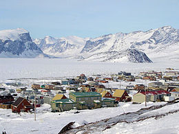
Pangnirtung (Inuktikut: Pang, Pangniqtuuq; ᐸᖕᓂᖅᑑᖅ) è un insediamento Inuit, nella Regione di Qikiqtaaluk, all'interno del territorio canadese del Nunavut. L'abitato è situato nell'Isola di Baffin. Secondo il censimento del 2016 la popolazione era di 1.481 abitanti, in crescita del 10,5% dal 2006.[1]
| Pangnirtung villaggio (hamlet) | |
|---|---|
| Pangniqtuuq - ᐸᖕᓂᖅᑑᖅ | |
 | |
| Localizzazione | |
| Stato | |
| Territorio | |
| Divisione censuaria | Regione di Qikiqtaaluk |
| Amministrazione | |
| Sindaco | Hezekiah Oshutapik |
| Territorio | |
| Coordinate | 66°08′52″N 65°41′58″W |
| Altitudine | 23 m s.l.m. |
| Superficie | 7,54 km² |
| Abitanti | 1 481 (2016) |
| Densità | 196,42 ab./km² |
| Altre informazioni | |
| Lingue | Inuktikut - Inglese |
| Cod. postale | X0A 0R0 |
| Prefisso | 867 |
| Fuso orario | UTC-5 |
| Cartografia | |
Pangnirtung è situato in una piccola pianura allo sbocco del Pangnirtung Fjord, un fiordo che al termine si incontra con il Cumberland Sound. L'area della città è di 7,54 km². Attualmente il sindaco è Ezekiah Ushutaapik.
Nome
Vi è una grande confusione sulla questione del nome. Gli abitanti di Pangnirtung affermeno infatti che il vero nome dell'abitato sia Panniqtuuq, che significa "luogo dei caribù maschi".[2] Comunque la popolazione nel 2005 ha rinunciato al voto per decidere un nuovo nome, preferendo mantenersi al vecchio Pangnirtung, ormai noto nella regione per le sue produzioni artistiche; la comunità è nota proprio per la propria scultura e pittura tradizionali.
Pangnirtung è soprannominata Svizzera dell'Artico[senza fonte].
Storia
Nel 1921 l'Hudson's Bay Company stabilì una propria postazione a Pangnirtung, seguita due anni dopo da una base della Royal Canadian Mounted Police. Il primo insegnante mandato dal governo regionale giunse nel paese nel 1956, mentre nel 1962 giunse il primo centro amministrativo.
Attività
La comunità è molto attiva nell'attività di pesca del rombo. Nel 2008 le autorità governative hanno approvato ufficialmente la proposta di costruzione di un porto.[3]
Note
- 2006 census [collegamento interrotto], su www12.statcan.ca.
- Qikiqtani Inuit Association - Pangnirtung Profile Archiviato il 10 maggio 2011 in Internet Archive.
- Nunavut Ministers Lobby for Federal Fishery Support, in Dollars and Sense: Northern Business and Economy, thesourdough.com, 3 giugno 2008. URL consultato il 21 agosto 2008 (archiviato dall'url originale il 14 febbraio 2009).
Bibliografia
- Arnaktauyok, Germaine. Stories from Pangnirtung. Edmonton: Hurtig, 1976. ISBN 0-88830-109-X
- Cross, L. D. 2003. "Woven, Not Carved: The Pangnirtung Tapestries Are Northern Art with Global Appeal". Arctic. 56: 310-314.
- Dale, Janis Elaine. The Relationship between the Physical Environment and Benthic Faunal Communities in Pangnirtung Fiord, Baffin Island, N.W.T. Ottawa: National Library of Canada = Bibliothèque nationale du Canada, 1993. ISBN 0-315-76445-7
- Ebisuda, Ken-ichi, Takashi Kunito, Reiji Kubota, and Shinsuke Tanabe. 2002. "Arsenic Concentrations and Speciation in the Tissues of Ringed Seals (Phoca Hispida) from Pangnirtung, Canada". Applied Organometallic Chemistry. 16, no. 8: 451.
- Hankins, Gerald W. Sunrise Over Pangnirtung The Story of Otto Schaefer, M.D. Komatik series, no. 6. Calgary: Arctic Institute of North America of the University of Calgary, 2000. ISBN 0-919034-97-7
- Langmark, Otto C. A., and C. O. Langmark. The Top of Baffin Island 140 Mountain Peaks (and Other Topographic Features) Around the South End of Pangnirtung Fjord, Baffin Island, N.W.T. [Thornhill, Ont.?]: Otto Langmark & Associates, 1990. ISBN 0-921779-92-5
- Neuman, Cheryl Lynn McKenna. Aeolian Processes and Landforms in South Pangnirtung Pass, Southeast Baffin Island, N.W.T., Canada. Ottawa: National Library of Canada, 1988. ISBN 0-315-40447-7
- O'Hara, Charles. Tourism and the Social Construction of Place A Case-Study of Tourists' Spatial Practices in Pangnirtung, Nunavut. Ottawa: National Library of Canada = Bibliothèque nationale du Canada, 2001. ISBN 0-612-57678-7
- Tarnocai, C., and Hugo Veldhuis. Soils and Trafficability of Pangnirtung Pass, Auyuittuq National Park Reserve. Ottawa: Research Branch (ECORC, BRC), Agriculture and Agri-Food Canada, 1998.
Altri progetti
 Wikimedia Commons contiene immagini o altri file su Pangnirtung
Collegamenti esterni
- (EN) Uqqurmiut Inuit Artist Association, su uqqurmiut.com.
| Controllo di autorità | VIAF (EN) 152382298 · LCCN (EN) no97043368 · GND (DE) 4726614-4 |
|---|
На других языках
[de] Pangnirtung
Pangnirtung (Pangniqtuuq), „Platz des Karibubullen“ ist nach Iqaluit und Pond Inlet die drittgrößte der acht Siedlungen der Baffininsel (Nunavut-Region Qikiqtaaluuk). Die Gemeinde hatte zum Stand der Volkszählung im Jahr 2016 1481 Einwohner und liegt im südöstlichen Teil der Baffininsel auf einem schmalen Küstenstreifen am Pangnirtung Fiord, einem nach Norden verlaufenden Seitenarm des Cumberland Sound (Tinnujivik), vor einem schroffen, etwa 800 m hohen Gebirgspanorama. Der Ort verfügt über Linienflugverbindung (Canadian North).[en] Pangnirtung
Pangnirtung (or Pang, also Pangniqtuuq, in syllabics: ᐸᖕᓂᖅᑑᖅ IPA: [paŋniqtuːq]) is an Inuit hamlet, in the Qikiqtaaluk Region of the Canadian territory of Nunavut, located on Baffin Island. Pangnirtung is situated on a coastal plain at the coast of Pangnirtung Fjord, a fjord which eventually merges with Cumberland Sound. As of January 2022, the mayor is Stevie Komoartok.[3][fr] Pangnirtung
Pangnirtung, ou Pangniqtuuq (en inuktitut : ᐸᖕᓂᖅᑑᖅ, /paŋ.niq.tuːq/, « lieu du caribou mâle ») est la deuxième ville du territoire autonome du Nunavut, au Canada. Elle se situe sur l'île de la Terre de Baffin, face à la mer de Baffin et au Groenland, à 300 km de la capitale territoriale d'Iqaluit.- [it] Pangnirtung
[ru] Пангниртанг
Пангниртанг[2] (англ. Pangnirtung, инуктитут ᐸᖕᓂᖅᑑᖅ) — эскимосская деревня, расположенная на острове Баффинова Земля в районе Кикиктани территории Нунавут, Канада. Координаты — 66°08´с. ш.; 65°45´з. д. Численность населения — 1,276 чел. (2001), что составляет приблизительно 9 % населения острова Баффинова Земля. Деревня расположена на прибрежной равнине фьорда Пангниртунг, который соединяется с заливом Камберленд. Площадь деревни 7.54 кв. км.Другой контент может иметь иную лицензию. Перед использованием материалов сайта WikiSort.org внимательно изучите правила лицензирования конкретных элементов наполнения сайта.
WikiSort.org - проект по пересортировке и дополнению контента Википедии
