world.wikisort.org - Canada
Vanderhoof[1] est une ville (District Municipality) située au centre de la province de Colombie-Britannique au Canada, dans le district régional de Bulkley-Nechako.
Cet article est une ébauche concernant une localité canadienne et la Colombie-Britannique.
Vous pouvez partager vos connaissances en l’améliorant (comment ?) selon les recommandations des projets correspondants.
| Vanderhoof | |||
| Administration | |||
|---|---|---|---|
| Pays | |||
| Province | |||
| Région | Plateau intérieur | ||
| Subdivision régionale | District régional de Bulkley-Nechako | ||
| Statut municipal | Municipalité de district | ||
| Constitution | 22 janvier 1926 | ||
| Démographie | |||
| Population | 4 064 hab. (2006) | ||
| Densité | 74 hab./km2 | ||
| Géographie | |||
| Coordonnées | 54° 00′ 51″ nord, 124° 00′ 32″ ouest | ||
| Superficie | 5 485 ha = 54,85 km2 | ||
| Divers | |||
| Fuseau horaire | UTC-8 | ||
| Code géographique | 5951007 | ||
| Localisation | |||
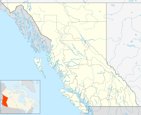
| Géolocalisation sur la carte : Colombie-Britannique
Géolocalisation sur la carte : Colombie-Britannique
| |||
| Liens | |||
| Site web | www.vanderhoof.ca | ||
| modifier |
|||


Démographie
Références
- (en) Référence sur le toponyme Vanderhoof dans la base de données officielle BCGNIS(BC Geographical Names Information System) sur le site GeoBC du Integrated Land Management Bureau
- « Statistique Canada - Profils des communautés de 2006 - Vanderhoof » (consulté le )
- « Statistique Canada - Profils des communautés de 2016 - Vanderhoof » (consulté le )
Liens externes
 Portail de la Colombie-Britannique
На других языках
[de] Vanderhoof (British Columbia)
Vanderhoof ist das geographische Zentrum von British Columbia, Kanada. Die Stadt liegt im Nechako Valley am Yellowhead Highway und ist umgeben von ertragreichem Farmland und ausgedehnten Wäldern. Sie liegt in einer Höhe von 674 m über dem Meeresspiegel. Nächstgelegene Stadt ist Prince George, 60 km östlich von Vanderhoof.[en] Vanderhoof, British Columbia
Vanderhoof is a district municipality near the geographical centre[3] of British Columbia, Canada. Covering 2.92 square kilometers.[4], it has a population of about 4,500 within town limits, and offers services to nearly 10,000 people in nearby rural communities. Its main industries are forestry, agriculture, and related businesses. Tourism is also growing, and mining operations are being developed in the area. It has many elementary schools, and one major secondary school, Nechako Valley Secondary School (NVSS), comprising School District 91 Nechako Lakes. The College of New Caledonia has a regional campus there.- [fr] Vanderhoof
[ru] Вандерхуф
Вандерхуф (англ. Vanderhoof) — окружной муниципалитет[en] в Канаде, расположенный в региональном округе Балкли-Нечако[en] региона «Внутреннее Плато[en]» вблизи географического центра[1] провинции Британская Колумбия. В пределах города проживает около четырёх с половиной тысяч жителей. Ввиду того, что рядом расположено несколько населённых пунктов, лишённых инфраструктуры, Вандерхуф в действительности обслуживает около 10 000 человек. Основными источниками дохода для города служат деревообрабатывающая и сельскохозяйственная промышленность, а также связанные с ними отрасли[2]. В Вандерхуфе располагаются несколько начальных и одна средняя школа — «Средняя школа долины Нечако» (англ. Nechako Valley High School), где обучаются 8-12 классы[3].Текст в блоке "Читать" взят с сайта "Википедия" и доступен по лицензии Creative Commons Attribution-ShareAlike; в отдельных случаях могут действовать дополнительные условия.
Другой контент может иметь иную лицензию. Перед использованием материалов сайта WikiSort.org внимательно изучите правила лицензирования конкретных элементов наполнения сайта.
Другой контент может иметь иную лицензию. Перед использованием материалов сайта WikiSort.org внимательно изучите правила лицензирования конкретных элементов наполнения сайта.
2019-2026
WikiSort.org - проект по пересортировке и дополнению контента Википедии
WikiSort.org - проект по пересортировке и дополнению контента Википедии