world.wikisort.org - Canada
Kitscoty est un village (village) du Comté de Vermilion River, situé dans la province canadienne d'Alberta.
Cet article est une ébauche concernant une localité canadienne et l’Alberta.
Vous pouvez partager vos connaissances en l’améliorant (comment ?) selon les recommandations des projets correspondants.
| Kitscoty | ||||
 Rue principale | ||||
| Administration | ||||
|---|---|---|---|---|
| Pays | ||||
| Province | ||||
| Subdivision régionale | Comté de Vermilion River | |||
| Statut municipal | village (village) | |||
| Maire | Daryl Frank[1] | |||
| Démographie | ||||
| Population | 846 hab. (2011) | |||
| Densité | 550 hab./km2 | |||
| Géographie | ||||
| Coordonnées | 53° 20′ 14″ nord, 110° 19′ 59″ ouest | |||
| Superficie | 153,88 ha = 1,538 8 km2 | |||
| Divers | ||||
| Langue(s) | Anglais | |||
| Fuseau horaire | Hiver : HNR (UTC-7) Été : HAR (UTC-6) |
|||
| Indicatif | 780, 587 et 825 | |||
| Code géographique | 4810041 | |||
| Localisation | ||||
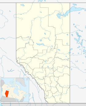
| Géolocalisation sur la carte : Alberta
Géolocalisation sur la carte : Alberta
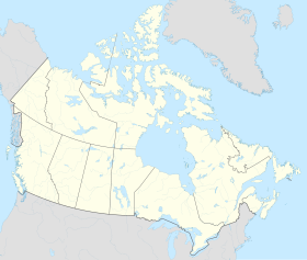
Géolocalisation sur la carte : Canada
| ||||
| Liens | ||||
| Site web | www.vokitscoty.ca | |||
| modifier |
||||

Démographie
En tant que localité désignée dans le recensement de 2011, Kitscoty a une population de 846 habitants dans 300 de ses 316 logements, soit une variation de 19.3% avec la population de 2006. Avec une superficie de 1,538 8 km2, village possède une densité de population de 549,779 0 hab/km2 en 2011[2].
Concernant le recensement de 2006, Kitscoty abritait 709 habitants dans 256 de ses 263 logements. Avec une superficie de 1,538 8 km2, village possédait une densité de population de 460,7 hab/km2 en 2006[3].

Références
- (en) Cet article est partiellement ou en totalité issu de l’article de Wikipédia en anglais intitulé « Kitscoty » (voir la liste des auteurs).
- (en) « Municipal Officials Search », sur Alberta Municipal Affairs (Affaires municipales d'Alberta) (consulté le )
- « Chiffres de population et des logements, Canada, provinces et territoires, et subdivisions de recensement (municipalités), recensements de 2011 et 2006 », sur Statistique Canada, (consulté le )
- « Chiffres de population et des logements, Canada, provinces et territoires, et subdivisions de recensement (municipalités), recensements de 2006 et 2001 - Données intégrales », sur Statistique Canada, (consulté le )
- « Statistique Canada - Profils des communautés de 2006 - Kitscoty » (consulté le )
- « Statistique Canada - Profils des communautés de 2016 - Kinuso » (consulté le )
Annexes
Articles connexes
- Liste des communautés d'Alberta
- Liste des villages d'Alberta
 Portail de l’Alberta
На других языках
[de] Kitscoty
Kitscoty ist eine Gemeinde im zentralen Osten von Alberta, Kanada, welche seit 1911 den Status eines Dorfes (englisch Village) hat.[2] Sie liegt in der Region Zentral-Alberta und etwa 230 Kilometer östlich von Edmonton bzw. etwa 25 Kilometer westlich von Lloydminster und damit der Grenze zur benachbarten Provinz Saskatchewan.[en] Kitscoty
Kitscoty is a village located in central Alberta, Canada. Situated at the junction of Highway 16 (Yellowhead Highway) and Highway 897 (the link to Cold Lake), the village is located approximately midway between Edmonton and Saskatoon (225 km (140 mi) and 295 km (183 mi) respectively). In addition, the village is within short commuting distance of Lloydminster. The CN railway tracks also pass through Kitscoty. The municipal office of the surrounding County of Vermilion River's is located in Kitscoty.- [fr] Kitscoty (Alberta)
Другой контент может иметь иную лицензию. Перед использованием материалов сайта WikiSort.org внимательно изучите правила лицензирования конкретных элементов наполнения сайта.
WikiSort.org - проект по пересортировке и дополнению контента Википедии