world.wikisort.org - Canada
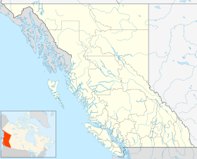
Le district de Kent est une municipalité de district de la Colombie-Britannique, au Canada, situé à 116 km à l'est de Vancouver. Il fait partie du district régional de Fraser Valley.
| Kent | |
| Administration | |
|---|---|
| Pays | |
| Province | |
| Démographie | |
| Population | 5 208 hab. (2006) |
| Densité | 31 hab./km2 |
| Géographie | |
| Coordonnées | 49° 14′ 17″ nord, 121° 45′ 45″ ouest |
| Superficie | 16 651 ha = 166,51 km2 |
| Divers | |
| Fuseau horaire | UTC-8 |
| Localisation | |
| modifier |
|
Kent comprend plusieurs communautés. La plus grande et la plus connue est Agassiz, la seule ville du district. Les autres communautés sont : Harrison Mills, Kilby, Mount Woodside, Kent Prairie, Sea Bird Island et Ruby Creek. On y trouve aussi des réserves indiennes qui ont leur propre gouvernement, dont celles de Sea Bird Island First Nation's sur l'île de Sea Bird et les environs.
Le recensement de 2006, version révisée, y dénombre 5 208 habitants[1],[2]
Références
- Portail de la Colombie-Britannique
На других языках
[de] Kent (British Columbia)
Kent ist eine Gebietsgemeinde („District Municipality“) am östlichen Rand des Lower Mainland der kanadischen Provinz British Columbia. Das Zentrum der Gemeinde hat sich in der Neighbourhood „Agassiz“ herausgebildet. Die Gemeinde gehört zum Fraser Valley Regional District und liegt am Nordufer des Fraser River, rund 120 km westlich von Vancouver. Die westliche Gemeindegrenze wird durch den Harrison River gebildet. Harrison Hot Springs liegt etwa 10 km nördlich von Kent.[en] Kent, British Columbia
The District of Kent is a district municipality located 116 kilometres (72 mi) east of Vancouver, British Columbia. Part of the Fraser Valley Regional District, Kent consists of several communities, the largest and most well-known being Agassiz—the only town in the municipality—Harrison Mills, Kilby, Mount Woodside, Kent Prairie, Sea Bird Island and Ruby Creek. Included within the municipality's boundaries are several separately-governed Indian reserves, including the Seabird Island First Nation's reserves on and around the island of the same name.- [fr] Kent (Colombie-Britannique)
Текст в блоке "Читать" взят с сайта "Википедия" и доступен по лицензии Creative Commons Attribution-ShareAlike; в отдельных случаях могут действовать дополнительные условия.
Другой контент может иметь иную лицензию. Перед использованием материалов сайта WikiSort.org внимательно изучите правила лицензирования конкретных элементов наполнения сайта.
Другой контент может иметь иную лицензию. Перед использованием материалов сайта WikiSort.org внимательно изучите правила лицензирования конкретных элементов наполнения сайта.
2019-2025
WikiSort.org - проект по пересортировке и дополнению контента Википедии
WikiSort.org - проект по пересортировке и дополнению контента Википедии

