world.wikisort.org - Canada
Chetwynd est une ville de la Colombie-Britannique située dans le district régional de Peace River.
Pour les articles homonymes, voir Chetwynd (homonymie).
Cet article est une ébauche concernant une localité canadienne et la Colombie-Britannique.
Vous pouvez partager vos connaissances en l’améliorant (comment ?) selon les recommandations des projets correspondants.
| Chetwynd | |||

| |||
| Administration | |||
|---|---|---|---|
| Pays | |||
| Province | |||
| Subdivision régionale | District régional de Peace River | ||
| Statut municipal | Ville | ||
| Maire | Evan Saugstad | ||
| Constitution | 1962 | ||
| Démographie | |||
| Population | 2 866 hab. (2006) | ||
| Densité | 45 hab./km2 | ||
| Géographie | |||
| Coordonnées | 55° 41′ 50″ nord, 121° 37′ 59″ ouest | ||
| Superficie | 6 432 ha = 64,32 km2 | ||
| Divers | |||
| Langue(s) | Anglais, Français | ||
| Fuseau horaire | -8 | ||
| Indicatif | +1 236, 250, 778 | ||
| Code géographique | 5955010 | ||
| Localisation | |||
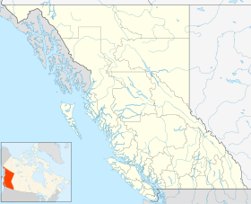
| Géolocalisation sur la carte : Colombie-Britannique
Géolocalisation sur la carte : Colombie-Britannique
| |||
| Liens | |||
| Site web | http://www.gochetwynd.com/siteengine/activepage.asp?bhcp=1 | ||
| modifier |
|||

Démographie
Économie
Municipalités limitrophes
 |
| |||
| ??? | N | Dawson Creek | ||
| O Chetwynd E | ||||
| S | ||||
| Prince George |
Notes et références
 Portail de la Colombie-Britannique
На других языках
[de] Chetwynd (British Columbia)
Chetwynd liegt in der kanadischen Provinz British Columbia. Die Stadt befindet sich zu Fuße der Rocky Mountains im Nordosten der Provinz und gehört zum Peace River Regional District.[en] Chetwynd, British Columbia
Chetwynd /ˈtʃɛtwɪnd/ is a district municipality located on the foothills of the Rocky Mountains in northeastern British Columbia, Canada. Situated on an ancient floodplain, it is the first town eastbound travellers encounter after emerging from the Rockies along Highway 97 and acts as the gateway to the Peace River Country. The town developed during the construction of infrastructure through the Rocky Mountains in the 1950s, and was used as a transshipment point during the construction of hydroelectric dams in the 1960s and 1970s and the new town of Tumbler Ridge in the early 1980s. Home to approximately 2,600 residents, the population has increased little if at all since the 1980s but is significantly younger than the provincial average.[3]- [fr] Chetwynd
Текст в блоке "Читать" взят с сайта "Википедия" и доступен по лицензии Creative Commons Attribution-ShareAlike; в отдельных случаях могут действовать дополнительные условия.
Другой контент может иметь иную лицензию. Перед использованием материалов сайта WikiSort.org внимательно изучите правила лицензирования конкретных элементов наполнения сайта.
Другой контент может иметь иную лицензию. Перед использованием материалов сайта WikiSort.org внимательно изучите правила лицензирования конкретных элементов наполнения сайта.
2019-2026
WikiSort.org - проект по пересортировке и дополнению контента Википедии
WikiSort.org - проект по пересортировке и дополнению контента Википедии