world.wikisort.org - Canada
Wakefield is a civil parish in Carleton County, New Brunswick, Canada,[2] located north on the west bank of the Saint John River north of Woodstock. It comprises two local service districts and part of a third, all of which are members of the Western Valley Regional Service Commission (WVRSC).[3]
Wakefield | |
|---|---|
Parish | |
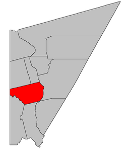 Location within Carleton County, New Brunswick | |
| Coordinates: 46.225°N 67.52°W | |
| Country | |
| Province | |
| County | Carleton |
| Erected | 1803 |
| Area | |
| • Land | 196.31 km2 (75.80 sq mi) |
| Population (2021)[1] | |
| • Total | 2,722 |
| • Density | 13.9/km2 (36/sq mi) |
| • Change 2016-2021 | |
| • Dwellings | 1,191 |
| Time zone | UTC-4 (AST) |
| • Summer (DST) | UTC-3 (ADT) |
The Census subdivision of Wakefield Parish shares the civil parish's borders.[1]

Origin of name
The parish may have been named for the city of Wakefield in Yorkshire, England.[4][5]
Historian William Francis Ganong noted that the name predated the parish's erection, appearing in 1801 in the Land Memorials.[6]
History
Wakefield was erected in 1803 within York County from unassigned lands north of Woodstock and Northampton Parishes.[7] It included Simonds and Wilmot Parishes, along with parts of Bright, Brighton, Northampton, Peel, Richmond, Southampton, Wicklow, and Woodstock Parishes as well as part of Maine claimed by New Brunswick.
Boundaries
Wakefield Parish is bounded:[2][8][9]
- on the north by the southern line of a land grant at the mouth of the Little Presque Isle Stream and its prolongation to the international border;
- on the east by the Saint John River;
- on the south by the southern line of a land grant on the Saint John River, opposite the junction of Route 105 and Newburg Road, prolonged to the Meduxnekeag River, and then the river to the international border;
- and on the west by Maine.
- It also includes all islands in front of it in the Saint John River. Whether the southern boundary extends through Pine Island or around it is not made clear by either the Territorial Division Act[2] or the New Brunswick cadastral grant map of the area.[8]
Evolution of boundaries
Wakefield originally extended north from Woodstock and Northampton Parishes to the mouth of Whitemarsh Creek and a point on the opposite side of the Saint John River, with its northern boundaries paralleling the two parishes to its south. Neither eastern nor western boundary was explicitly mentioned, simply "all that tract of country in the County of York" between the southern and northern boundaries of Wakefield.[7]
In 1830 all of Wakefield east of the channel of the Saint John River was erected as Brighton Parish.[10] This put at least one island in each parish.
In 1838 all of Wakefield south of the Meduxnekeag River was transferred to Woodstock Parish.[11]
In 1842 the northern part of Wakefield was erected as Simonds Parish.[12] Simonds included Wilmot Parish and a small part of Wicklow Parish. Later the same year New Brunswick's land boundary with Maine was settled by the Webster–Ashburton Treaty, ending Wakefield's implicit claim to part of Maine.
In 1850 the boundary within the Saint John River was altered, making all islands in front of Wakefield part of the parish.[13]
In 1854 the southern boundary of Wakefield was extended across the Meduxnekeag to include parts of two grants that straddled the river.[14]
Local service districts
All local service districts assess for the basic LSD services of fire protection, police services, land use planning, emergency measures, and dog control.[15]
Wakefield Parish
The local service district of the parish of Wakefield originally comprised the entire parish. Today the LSD is divided into two taxing authorities, the larger Wakefield (Inside) including most of the LSD[16] and Wakefield (Outside) in the northeastern part of the LSD, containing the communities of Victoria Corner and Waterville.
The parish LSD was established in 1966[17] to assess for fire protection. Community services were added in 1967.[18] Recreational services were added in 1985 to the new taxing authority of Wakefield Inside.[19]
Today both taxing authorities assess for community & recreational services.[15] The taxing authorities are 215.00 Wakefield (Inside) and 215.01 Wakefield (Outside).
LSD advisory committee: Unknown.
Somerville
Somerville comprises a rough triangle around Route 103, Route 130, and the Somerville Road with an extension south along Route 103.[16]
Somerville was established in 1971[20] to add street lighting and first aid & ambulance services; community services were removed, probably in error. Community services were restored and first aid & ambulance services removed in the rewrite of the LSD regulation in 1974.[21]
Today Somerville assesses for street lighting.[15] The taxing authority is 222.00 Somerville.
LSDAC: Unknown.
Lakeville
Lakeville includes a single land grant in Wakefield Parish, located on the western side Route 560, north of the prolongation of the Estey Road.[16]
Communities
Communities at least partly within the parish;[8][9][22]
- Belleville
- Briggs Corner
- Hartford
- Jackson Falls
- Jacksontown
- Jacksonville
- Lindsay
- Lower Wakefield
- Lower Waterville
- McKenna
- Oakville
- Rosedale
- Somerville
- South Greenfield
- Upper Waterville
- Victoria Corner
- Wakefield
- Waterville
Bodies of water
Bodies of water[lower-alpha 1] at least partly in the parish:[8][9][22]
- Meduxnekeag River
- Saint John River
- Little Presque Isle Stream
- Lanes Creek
- Bennetts Lake
- Cox Lake
- Mud Lake
- Payson Lake
- York Lake
Other notable places
Parks, historic sites, and other noteworthy places at least partly in the parish.[8][9][22][23]
- Iron Ore Hill
- Meduxnekeag Valley Protected Natural Area
Demographics
Population
|
LanguageMother tongue (2016)[26]
|
See also
- List of parishes in New Brunswick
Notes
- Not including brooks, ponds or coves.
References
- "Census Profile". Statistics Canada. 26 October 2022. Retrieved 30 October 2022.
- "Chapter T-3 Territorial Division Act". Government of New Brunswick. Retrieved 13 November 2020.
- "Communities in each of the 12 Regional Service Commissions (RSC) / Les communautés dans chacune des 12 Commissions de services régionaux (CSR)" (PDF), Government of New Brunswick, July 2017, retrieved 1 February 2021
- Ganong, William F. (1896). A Monograph of the Place-Nomenclature of the Province of New Brunswick. Royal Society of Canada. p. 279. Retrieved 17 March 2021.
- "Wakefield Parish". Provincial Archives of New Brunswick. Retrieved 16 April 2021.
- Ganong, William F. (1906). Additions and Corrections to Monographs on the Place-Nomenclature, Cartography, Historic Sites, Boundaries and Settlement-origins of the Province of New Brunswick. Royal Society of Canada. p. 52. Retrieved 12 April 2021.
- "43 Geo. III c. 5 An Act for erecting the Upper part of the County of York into a distinct Town and Parish.". Acts of the General Assembly of His Majesty's Province of New-Brunswick. Passed in the Year 1803. Saint John, New Brunswick: Government of New Brunswick. 1803. p. 480. Retrieved 27 March 2021.
- "No. 101". Provincial Archives of New Brunswick. Department of Natural Resources and Energy Development. Retrieved 27 June 2021.
- "288" (PDF). Transportation and Infrastructure. Government of New Brunswick. Retrieved 27 June 2021. Remainder of parish on mapbooks 304, 305, 323, and 324 at same site.
- "10 & 11 Geo. IV c. 6 An Act for erecting a part of the Parish of Wakefield, in the County of York, into a separate and distinct Town or Parish.". Acts of the General Assembly of His Majesty's Province of New Brunswick, Passed in the Year 1830. Fredericton: Government of New Brunswick. 1830. pp. 5–6. Retrieved 27 March 2021.
- "1 Vic. c. 31 An Act to enlarge and define the Boundaries of the Parish of Woodstock.". Acts of the General Assembly of Her Majesty's Province of New Brunswick, Passed in the Year 1838. Fredericton: Government of New Brunswick. 1838. p. 76. Retrieved 27 March 2021.
- "5 Vic. c. 17 An Act to erect the upper part of the Parish of Wakefield, in the County of Carleton, into a separate and distinct Town or Parish.". Acts of the General Assembly of Her Majesty's Province of New Brunswick, Passed in the Year 1842. Fredericton: Government of New Brunswick. 1842. p. 13. Retrieved 27 March 2021.
- "13 Vic. c. 51 An Act to consolidate all the Laws now in force for the division of the Province into Counties, Towns and Parishes.". Acts of the General Assembly of Her Mjaesty's Province of New Brunswick, Passed in the Year 1850. Fredericton: Government of New Brunswick. 1850. pp. 142–152, 145–149. Retrieved 27 March 2021. Book was poorly proofread, resulting in title typo and reuse of page numbers 145–152.
- "Chapter 1.". The Revised Statutes of New Brunswick Volume 1. Fredericton: Government of New Brunswick. 1854. pp. 2–19. Retrieved 27 March 2021.
- "2020 Local Government Statistics for New Brunswick" (PDF). Department of Environment and Local Government. p. 55. Retrieved 16 January 2021.
- "New Brunswick Regulation 84-168 under the Municipalities Act (O.C. 84-582)". Government of New Brunswick. Retrieved 16 January 2021.
- "Regulation 66–41 under the Municipalities Act (O. C. 66–968)". The Royal Gazette. Fredericton. 124: 604–605. 21 December 1966.
- "Regulation 67–130 under the Municipalities Act (O. C. 67–1196)". The Royal Gazette. Fredericton. 126: 10–11. 3 January 1968.
- New Brunswick Regulation 96-76.
- "Regulation 71–101 under the Municipalities Act (O. C. 71–690)". The Royal Gazette. Fredericton. 129: 736. 27 October 1971.
- "Regulation 74–102 under the Municipalities Act (O. C. 74–651)". New Brunswick Regulations 1974. Fredericton: 811–904. 1975.
- "Search the Canadian Geographical Names Database (CGNDB)". Government of Canada. Retrieved 28 June 2021.
- "Explore New Brunswick's Protected Natural Areas". GeoNB. Retrieved 1 July 2021.
- Statistics Canada: 1996, 2001, 2006 census
- 2011 Statistics Canada Census Profile: Wakefield Parish, New Brunswick
- "Census Profile, 2016 Census Wakefield, Parish [Census subdivision], New Brunswick". Statistics Canada. Retrieved 6 September 2019.
Places adjacent to Wakefield Parish, New Brunswick | ||||||||||||||||
|---|---|---|---|---|---|---|---|---|---|---|---|---|---|---|---|---|
| ||||||||||||||||
Subdivisions of New Brunswick | |
|---|---|
| Subdivisions |
|
| Cities | |
| Counties | |
| |
Другой контент может иметь иную лицензию. Перед использованием материалов сайта WikiSort.org внимательно изучите правила лицензирования конкретных элементов наполнения сайта.
WikiSort.org - проект по пересортировке и дополнению контента Википедии