world.wikisort.org - Canada
Saint-Antonin (French pronunciation: [sɛ̃.t‿ɑ̃tɔnɛ̃]) is a city in the Bas-Saint-Laurent region of Quebec, Canada, a few kilometres south of the city of Rivière-du-Loup, in Rivière-du-Loup Regional County Municipality. The municipality is named after Louis-Antonin or Antoine Proulx (1810-1896), priest of Fraserville (Rivière-du-Loup) and was founded in 1856.
 | This article uses bare URLs, which are uninformative and vulnerable to link rot. (August 2022) |
 | This article may be expanded with text translated from the corresponding article in French. (April 2010) Click [show] for important translation instructions.
|
Saint-Antonin | |
|---|---|
City | |
 | |
 Location within Rivière-du-Loup RCM | |
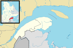  Saint-Antonin Location in eastern Quebec | |
| Coordinates: 47°46′N 69°29′W[1] | |
| Country |  Canada Canada |
| Province |  Quebec Quebec |
| Region | Bas-Saint-Laurent |
| RCM | Rivière-du-Loup |
| Constituted | August 30, 1856 |
| Government | |
| • Mayor | Réal Thibault |
| • Federal riding | Montmagny—L'Islet—Kamouraska—Rivière-du-Loup |
| • Prov. riding | Rivière-du-Loup-Témiscouata |
| Area | |
| • Total | 175.10 km2 (67.61 sq mi) |
| • Land | 175.94 km2 (67.93 sq mi) |
| There is an apparent contradiction between two authoritative sources | |
| Population (2011)[3] | |
| • Total | 4,027 |
| • Density | 22.9/km2 (59/sq mi) |
| • Pop 2006-2011 |  6.5% 6.5% |
| • Dwellings | 1,650 |
| Postal code(s) | G0L 2J0 |
| Area code(s) | 418 and 581 |
Highways   A-85 (TCH) A-85 (TCH) |  Route 185 (TCH) Route 185 (TCH) |
| Website | www |
On November 1, 2014, Saint-Antonin was changed from a parish municipality to a (regular) municipality.[4]
Demographics
Population trend:[5]
- Population in 2021: 4,338 (2016 to 2021 population change: 7.1%)
- Population in 2016: 4,049
- Population in 2011: 4,027
- Population in 2006: 3,780
- Population in 2001: 3,395
- Population in 1996: 3,368
Private dwellings occupied by usual residents: 1,889 (total dwellings: 1,990)
Mother tongue:
- English as first language: 0.4%
- French as first language: 99.5%
- English and French as first language: 0.1%
- Other as first language: 0.1%
Education
Centre de services scolaire de Kamouraska - Rivière-du-Loup operates francophone public schools:
- École Lanouette [6]
The Eastern Shores School Board operates anglophone public schools:
- Metis Beach School in Métis-sur-Mer[7]
References
- "Reference number 55652 in Banque de noms de lieux du Québec". toponymie.gouv.qc.ca (in French). Commission de toponymie du Québec.
- "Geographic code 12015 in the official Répertoire des municipalités". www.mamh.gouv.qc.ca (in French). Ministère des Affaires municipales et de l'Habitation.
- "(Code 2412015) Census Profile". 2011 census. Statistics Canada. 2012.
- "Modifications aux municipalités du Québec" (PDF). Modifications Aux Municipalités du Québec. Institut de la statistique du Québec. November 2014. ISSN 1715-6408.
- Statistics Canada: 1996, 2001, 2006, 2011, 2016, 2021 census
- https://lanouette.csskamloup.gouv.qc.ca/
- "Metis Beach School - Believe, Achieve, Succeed……".
- Répertoire des municipalités du Québec
- Commission de toponymie du Québec
- Affaires municipales et régions - cartes régionales
External links
 Media related to Saint-Antonin, Quebec at Wikimedia Commons


Adjacent Municipal Subdivisions | ||||||||||||||||
|---|---|---|---|---|---|---|---|---|---|---|---|---|---|---|---|---|
| ||||||||||||||||


| Cities & Towns | |
|---|---|
| Municipalities |
|
| Parishes | |
| |


На других языках
- [en] Saint-Antonin, Quebec
[fr] Saint-Antonin (Québec)
La ville de Saint-Antonin est située à quelques kilomètres au sud de la ville de Rivière-du-Loup dans la municipalité régionale de comté de Rivière-du-Loup, dans la région administrative du Bas-Saint-Laurent, au Québec, au Canada[1]. On y retrouve plusieurs tourbières et exploitations agricoles. À Saint-Antonin se déroule aussi le Festival Country de St-Antonin à chaque mois de juin[2], la Super démolition en juillet ainsi que le Super motocross dans le mois d'août[3].Текст в блоке "Читать" взят с сайта "Википедия" и доступен по лицензии Creative Commons Attribution-ShareAlike; в отдельных случаях могут действовать дополнительные условия.
Другой контент может иметь иную лицензию. Перед использованием материалов сайта WikiSort.org внимательно изучите правила лицензирования конкретных элементов наполнения сайта.
Другой контент может иметь иную лицензию. Перед использованием материалов сайта WikiSort.org внимательно изучите правила лицензирования конкретных элементов наполнения сайта.
2019-2026
WikiSort.org - проект по пересортировке и дополнению контента Википедии
WikiSort.org - проект по пересортировке и дополнению контента Википедии