world.wikisort.org - Canada
Macdonald, Meredith and Aberdeen Additional is a township in Algoma District, Ontario, Canada. Originally surveyed as separate geographical townships, Macdonald and Meredith were incorporated as a single, municipal township in 1892. The geographical township of Aberdeen Additional was added to Macdonald and Meredith township in 1899 to create the municipal township of Macdonald, Meredith and Aberdeen Additional.
Macdonald, Meredith and Aberdeen Additional | |
|---|---|
Township (single-tier) | |
| Township of Macdonald, Meredith and Aberdeen Additional | |
 Municipal office in Echo Bay | |
 Macdonald, Meredith and Aberdeen Additional | |
| Coordinates: 46°29′N 84°04′W | |
| Country | Canada |
| Province | Ontario |
| District | Algoma |
| Settled | mid 19th century |
| Incorporated | 1899 |
| Government | |
| • Type | Township |
| • Mayor | Lynn Watson |
| • MP | Carol Hughes (NDP) |
| • MPP | Michael Mantha (NDP) |
| Area | |
| • Land | 164.05 km2 (63.34 sq mi) |
| Population (2016)[1] | |
| • Total | 1,609 |
| • Density | 9.8/km2 (25/sq mi) |
| Time zone | UTC-5 (EST) |
| • Summer (DST) | UTC-4 (EDT) |
| Postal Code | P0S 1C0 |
| Area code(s) | 705, 249 |
| Website | Official website |
The township encompasses the unincorporated communities of Echo Bay, Bar River and Sylvan Valley.
Communities
Bar River is a small hamlet straddling the boundary between the townships of Macdonald, Meredith and Aberdeen Additional and Laird.
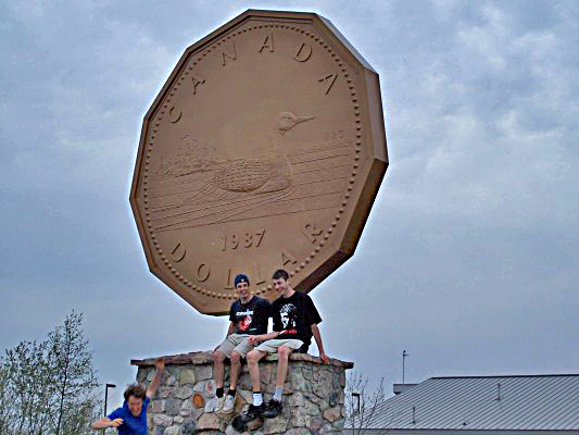
Echo Bay is located on the shores of the eponymous Echo Bay and Lake George. The community is home to a big loonie, similar to the Big Nickel in Sudbury, around 260 kilometres (160 mi) eastward. Robert-Ralph Carmichael, one of the Canadian dollar coin's designers, lived near Echo Bay.
Demographics
In the 2021 Census of Population conducted by Statistics Canada, Macdonald, Meredith and Aberdeen Additional had a population of 1,513 living in 603 of its 803 total private dwellings, a change of -6% from its 2016 population of 1,609. With a land area of 163.26 km2 (63.04 sq mi), it had a population density of 9.3/km2 (24.0/sq mi) in 2021.[2]
| 2021 | 2016 | 2011 | |
|---|---|---|---|
| Population | 1,513 (-6.0% from 2016) | 1,609 (9.9% from 2011) | 1,464 (-5.5% from 2006) |
| Land area | 163.26 km2 (63.04 sq mi) | 164.05 km2 (63.34 sq mi) | 163.52 km2 (63.14 sq mi) |
| Population density | 9.3/km2 (24/sq mi) | 9.8/km2 (25/sq mi) | 9.0/km2 (23/sq mi) |
| Median age | 45.6 (M: 44.8, F: 46) | 45.3 (M: 43.0, F: 46.2) | |
| Total private dwellings | 600 | 860 | 797 |
| Median household income | $74,496 |
Population trend:[8]
- Population in 2016: 1,609
- Population in 2011: 1,464
- Population in 2006: 1,550
- Population in 2001: 1,452
- Population in 1996: 1,521
- Population in 1991: 1,548
See also
- List of townships in Ontario
References
- "Macdonald, Meredith and Aberdeen Additional census profile". 2016 Census of Population. Statistics Canada. Retrieved 2017-10-11.
- "Population and dwelling counts: Canada, provinces and territories, census divisions and census subdivisions (municipalities), Ontario". Statistics Canada. February 9, 2022. Retrieved April 2, 2022.
- "2021 Community Profiles". 2021 Canadian Census. Statistics Canada. February 4, 2022. Retrieved 2022-04-27.
- "2016 Community Profiles". 2016 Canadian Census. Statistics Canada. August 12, 2021. Retrieved 2017-10-11.
- "2011 Community Profiles". 2011 Canadian Census. Statistics Canada. March 21, 2019. Retrieved 2012-02-17.
- "2006 Community Profiles". 2006 Canadian Census. Statistics Canada. August 20, 2019.
- "2001 Community Profiles". 2001 Canadian Census. Statistics Canada. July 18, 2021.
- Statistics Canada: 1996, 2001, 2006 census, 2011, 2016
External links
 Media related to Macdonald, Meredith and Aberdeen Additional at Wikimedia Commons
- Official website
Places adjacent to Macdonald, Meredith and Aberdeen Additional | ||||||||||||||||
|---|---|---|---|---|---|---|---|---|---|---|---|---|---|---|---|---|
| ||||||||||||||||

| Authority control |
|
|---|
Другой контент может иметь иную лицензию. Перед использованием материалов сайта WikiSort.org внимательно изучите правила лицензирования конкретных элементов наполнения сайта.
WikiSort.org - проект по пересортировке и дополнению контента Википедии