world.wikisort.org - Canada
L'Isle-aux-Allumettes is a municipality in the Outaouais region, part of the Pontiac Regional County Municipality, Quebec, Canada. The municipality consists primarily of Allumette Island (in French Île aux Allumettes), and also includes Morrison Island, Marcotte Island, and some minor islets, all in the Ottawa River north of Pembroke.
L'Isle-aux-Allumettes | |
|---|---|
Municipality | |
 | |
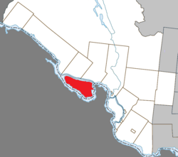 Location within Pontiac RCM | |
 L'Isle-aux-Allumettes Location in SW Quebec | |
| Coordinates: 45°52′N 77°04′W[1] | |
| Country | Canada |
| Province | Quebec |
| Region | Outaouais |
| RCM | Pontiac |
| Constituted | December 30, 1998 |
| Government | |
| • Mayor | Corey Spence |
| • Federal riding | Pontiac |
| • Prov. riding | Pontiac |
| Area | |
| • Total | 210.60 km2 (81.31 sq mi) |
| • Land | 185.94 km2 (71.79 sq mi) |
| Population (2021)[3] | |
| • Total | 1,382 |
| • Density | 7.4/km2 (19/sq mi) |
| • Pop (2016-21) | |
| • Dwellings | 1,124 |
| Time zone | UTC−5 (EST) |
| • Summer (DST) | UTC−4 (EDT) |
| Postal code(s) | J0X 1M0 |
| Area code | 819 |
| Highways | |
| Website | www |
In the past, the island and municipalities have been spelled in French in various ways:[4]
- Isle-des-Allumettes
- L'Île-Allumettes
- Île-aux-Allumettes
Etymology
The name Isle-aux-Allumettes literally means "Island of Matches", and may refer to a box of matches that was left behind. In 1686, Chevalier de Troyes wrote about the island: “A Jesuit passing here another time forgot a box of matches which he carried to make a fire. This is why the Voyageurs gave the name “L’Isle-aux-Allumettes”.[5]
Another theory claims that the place was named for the reeds that grew on the island which were used as matches.[5]
Geography
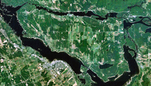
Allumette Island is 22 kilometres (14 mi) long and 12 kilometres (7.5 mi) wide, making it the largest island within the Ottawa River along its entire course. At this point the Ottawa River has widened into a lake, called Allumette Lake, which is 52 km (32 mi) long and has a total surface area of 120 km2 (46 sq mi).[6]
The municipality consists mostly of agricultural land. Its population centres are Chapeau, Desjardinsville, Demers Centre, and Saint-Joseph.[7]
History
The Kichesipirini Algonquins first occupied the site in order to maintain control of trade on the Ottawa River. For this reason, Samuel de Champlain named it Isle des Algoumequins during his trip of 1613. In 1650, this native population was almost entirely exterminated by the Iroquois.[6]
In his memoirs written during the second half of the 17th century, Nicolas Perrot made mention of the "One-Eyed Man's Island otherwise called Matches Island" ("Isle du Borgne autrement ditte l'Isle des Allumettes"). "One-Eyed" was a reference to the disability of Tessouat, an Algonquin chief in the region. The name "Allumettes" was first given to the rapids south-east of the island; a map from 1680 refers to these as Sault des Allumettes (Matches Falls).[6]
It was not until 1818 that Europeans began to settle on the island. They worked mostly as loggers or for the Hudson's Bay Company which had a fur trading post just upstream at Fort William. The preferred transport route was still the river, so most families build their homes on the southside of the island where the church of Saint-Alphonse-de-l'Île-aux-Allumettes Parish was built in 1840.[6] The Île-aux-Allumettes Township was formed in 1847,[8] and its first mayor was Andrew Whelan.[7]
An intense fire destroyed almost all the buildings in 1853 and, thereafter, the population settled more toward the northern part, on the current site of Chapeau village.[6] In 1874, the village of Chapeau separated from the township and became an incorporated municipality,[9] with Patrick Cunningham as the first mayor.[7]
In 1910, the parish of Saint-Joseph-de-l'Île-aux-Allumettes was established on the eastern part of the island, leading to the formation of the Municipality of L'Isle-aux-Allumettes-Partie-Est in 1920.[10]
On December 30, 1998, the municipality of Chapeau Village and the township municipalities of L'Isle-aux-Allumettes and L'Isle-aux-Allumettes-Part-East were merged into the new Municipality of L'Isle-aux-Allumettes.[4]

Demographics
Population
| 2021 | 2016 | 2011 | |
|---|---|---|---|
| Population | 1,382 (+3.6% from 2016) | 1,334 (-0.8% from 2011) | 1,345 (-6.8% from 2006) |
| Land area | 185.94 km2 (71.79 sq mi) | 186.02 km2 (71.82 sq mi) | 185.87 km2 (71.76 sq mi) |
| Population density | 7.4/km2 (19/sq mi) | 7.2/km2 (19/sq mi) | 7.2/km2 (19/sq mi) |
| Median age | 50.0 (M: 48.8, F: 50.8) | 50.6 (M: 49.8, F: 51.3) | 47.7 (M: 47.3, F: 47.9) |
| Total private dwellings | 1,124 | 1,126 | 1,122 |
| Median household income | $67,000 | $54,400 | $.N/A |
|
| ||||||||||||||||||||||||||||||||||||
| Population amounts prior to 1998 are total of L'Isle-aux-Allumettes CT, L'Isle-aux-Allumettes-Partie-Est CT, and Chapeau VL. Source: Statistics Canada[16] | |||||||||||||||||||||||||||||||||||||
Language
Mother tongue (2021):[3]
- English as first language: 75.7%
- French as first language: 18.1%
- English and French as first language: 3.6%
- Other as first language: 2.2%
Local government
List of former mayors (since formation of current municipality):[17]
- Jérôme Sallafranque (1998–1999)
- Denzil Spence (1999–2005)
- Brian Adam (2005–2009)
- Winston Sunstrum (2009–2021)
- Corey Spence (2021–present)
See also
- List of municipalities in Quebec
References
- "Reference number 350425 in Banque de noms de lieux du Québec". toponymie.gouv.qc.ca (in French). Commission de toponymie du Québec.
- "L'Isle-aux-Allumettes". Répertoire des municipalités (in French). Ministère des Affaires municipales et de l'Habitation. Retrieved 25 October 2022.
- "L'Isle-aux-Allumettes, Municipalité (MÉ) Census Profile, 2021 Census of Population". www12.statcan.gc.ca. Government of Canada - Statistics Canada. Retrieved 25 October 2022.
- "Municipalité de canton L'Isle-aux-Allumettes" (in French). Commission de toponymie du Québec. Retrieved 2008-04-14.
- "History". www.isle-aux-allumettes.com. Municipalité de L'Isle-aux-Allumettes. Retrieved 25 October 2022.
- "Île aux Allumettes" (in French). Commission de toponymie du Québec. Retrieved 2008-04-14.
- "Allumettes Island". Pontiac MRC Gateway. Archived from the original on October 7, 2006. Retrieved 2008-04-21.
- "Canton d'Île-aux-Allumettes" (in French). Commission de toponymie du Québec. Retrieved 2008-04-14.
- "Municipalité de village de Chapeau" (in French). Commission de toponymie du Québec. Retrieved 2008-04-14.
- "L'Isle-aux-Allumettes-Partie-Est" (in French). Commission de toponymie du Québec. Retrieved 2008-04-14.
- "2021 Community Profiles". 2021 Canadian Census. Statistics Canada. February 4, 2022. Retrieved 2022-04-27.
- "2016 Community Profiles". 2016 Canadian Census. Statistics Canada. August 12, 2021. Retrieved 2019-11-19.
- "2011 Community Profiles". 2011 Canadian Census. Statistics Canada. March 21, 2019. Retrieved 2014-02-01.
- "2006 Community Profiles". 2006 Canadian Census. Statistics Canada. August 20, 2019.
- "2001 Community Profiles". 2001 Canadian Census. Statistics Canada. July 18, 2021.
- 1996, 2001, 2006, 2011 census
- "Répertoire des entités géopolitiques: L'Isle-aux-Allumettes (municipalité) 30.12.1998 - ..." www.mairesduquebec.com. Institut généalogique Drouin. Retrieved 25 October 2022.
External links
![]() Media related to L'Isle-aux-Allumettes at Wikimedia Commons
Media related to L'Isle-aux-Allumettes at Wikimedia Commons
Adjacent Municipal Subdivisions | ||||||||||||||||
|---|---|---|---|---|---|---|---|---|---|---|---|---|---|---|---|---|
| ||||||||||||||||
| Municipalities | |
|---|---|
| Townships | |
| Villages | |
| Unorganized territories | |
| |
| Authority control |
|
|---|
На других языках
- [en] L'Isle-aux-Allumettes
[fr] L'Isle-aux-Allumettes
L'Isle-aux-Allumettes est une municipalité de village du Québec, située dans la MRC de Pontiac en Outaouais[1].Другой контент может иметь иную лицензию. Перед использованием материалов сайта WikiSort.org внимательно изучите правила лицензирования конкретных элементов наполнения сайта.
WikiSort.org - проект по пересортировке и дополнению контента Википедии