world.wikisort.org - Canada
Census Division No. 10 of Newfoundland and Labrador is composed of the Labrador region of the province, excluding Nunatsiavut. It has a land area of 199,703 km² (77,105.8 sq mi) and at the 2016 census had a population of 24,639,[1] up from 24,111 in 2011.[2] Its two major population centres are the towns of Happy Valley-Goose Bay[3] and Labrador City.
Division No. 10 | |
|---|---|
Census division | |
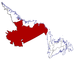 Location of Division No. 10 in Newfoundland and Labrador | |
| Coordinates: 52°57′N 66°55′W | |
| Country | Canada |
| Province | Newfoundland and Labrador |
| Area | |
| • Total | 199,703.36 km2 (77,105.90 sq mi) |
| As of 2016 | |
| Population (2016)[1] | |
| • Total | 24,639 |
| • Density | 0.12/km2 (0.32/sq mi) |
Demographics
In the 2021 Census of Population conducted by Statistics Canada, Division No. 10 had a population of 24,332 living in 9,518 of its 10,941 total private dwellings, a change of -1.2% from its 2016 population of 24,639. With a land area of 191,691.09 km2 (74,012.34 sq mi), it had a population density of 0.1/km2 (0.3/sq mi) in 2021.[4]
| Ethnic Origin | Percentage of Population |
|---|---|
| Canadian | 41.8% |
| English | 30.4% |
| First Nations (North American Indian) | 15.8% |
| Inuit | 14.8% |
| Métis | 13.6% |
| Irish | 12.5% |
| Scottish | 7.1% |
| French | 6.4% |
| German | 1.8% |
| British Isles origins, not included elsewhere | 0.9% |
| Newfoundlander | 0.8% |
Towns
- Cartwright
- Charlottetown
- Forteau
- Happy Valley-Goose Bay
- Labrador City
- L'Anse-au-Clair
- L'Anse-au-Loup
- Mary's Harbour
- North West River
- Pinware
- Port Hope Simpson
- Red Bay
- St. Lewis
- Wabush
- West St. Modeste
Unorganized subdivisions
- Subdivision A (Includes: L'Anse-Amour, Capstan Island)
- Subdivision B (Includes: Lodge Bay, Paradise River, Black Tickle, Norman's Bay, Pinsent's Arm, William's Harbour)
- Subdivision C (Includes: Sheshatshiu, Mud Lake)
- Subdivision D (Includes: Churchill Falls)
- Subdivision E (Includes: Natuashish)
References
- "Census Profile, 2016 Census: Division No. 10, Census division [Census division], Newfoundland and Labrador". Statistics Canada. Retrieved October 13, 2019.
- "Census Profile - Division No. 10, Census division". Statistics Canada. Retrieved 2 March 2012.
- "Happy Valley-Goose Bay, Newfoundland and Labrador (Town) Census Subdivision". Community Profiles. Statistics Canada.
- "Population and dwelling counts: Canada and census divisions". Statistics Canada. February 9, 2022. Retrieved April 2, 2022.
- "Census Profile, 2016 Census".
Sources
- "(Code 1010) Census Profile". 2011 census. Statistics Canada. 2012.
Places adjacent to Division No. 10, Newfoundland and Labrador | ||||||||||||||||
|---|---|---|---|---|---|---|---|---|---|---|---|---|---|---|---|---|
| ||||||||||||||||
Subdivisions of Newfoundland and Labrador | |
|---|---|
| Subdivisions and statistical units |
|
| Communities |
|
| Cities | |
| |
На других языках
- [en] Division No. 10, Newfoundland and Labrador
[ru] Переписной район №10 (Ньюфаундленд и Лабрадор)
Переписной район № 10 (англ. Census Division No. 10) — переписной район[en] в канадской провинции Ньюфаундленд и Лабрадор. Состоит из региона Лабрадор исключая территорию Нунатсиавут. Согласно переписи 2016 года, население района составляет 24 639 человек, а площадь — 199 703 км²[1]. Крупнейшими городами района являются Хаппи-Валли-Гуз-Бей и Лабрадор-Сити.Текст в блоке "Читать" взят с сайта "Википедия" и доступен по лицензии Creative Commons Attribution-ShareAlike; в отдельных случаях могут действовать дополнительные условия.
Другой контент может иметь иную лицензию. Перед использованием материалов сайта WikiSort.org внимательно изучите правила лицензирования конкретных элементов наполнения сайта.
Другой контент может иметь иную лицензию. Перед использованием материалов сайта WikiSort.org внимательно изучите правила лицензирования конкретных элементов наполнения сайта.
2019-2026
WikiSort.org - проект по пересортировке и дополнению контента Википедии
WikiSort.org - проект по пересортировке и дополнению контента Википедии