world.wikisort.org - Brasile
Caraguatatuba è una microregione dello Stato di San Paolo in Brasile, appartenente alla mesoregione di Vale do Paraíba Paulista.
|
Questa voce o sezione sull'argomento Brasile non cita le fonti necessarie o quelle presenti sono insufficienti.
|
| Caraguatatuba microregione | |
|---|---|
| Localizzazione | |
| Stato | |
| Stato federato | |
| Mesoregione | Vale do Paraíba Paulista |
| Territorio | |
| Coordinate | 23°37′12″S 45°24′46″W |
| Superficie | 1 947,7 km² |
| Abitanti | 281 532 (2006) |
| Densità | 144,55 ab./km² |
| Altre informazioni | |
| Fuso orario | UTC-3 |
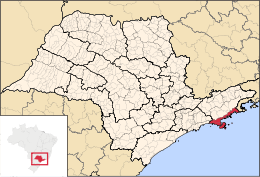
| Cartografia | |
 Caraguatatuba | |
 | |
Comuni
Comprende 4 comuni:
На других языках
[en] Microregion of Caraguatatuba
The Microregion of Caraguatatuba (Portuguese: Microrregião de Caraguatatuba), often referred as Litoral Norte (Northern Coastline), is a microregion in the easternmost coastal part of São Paulo State, Brazil. The microregion is bordered by the state of Rio de Janeiro to the east. It is a famous touristic destination, mainly because of the 160 beaches. According to IBGE, Caraguatatuba Microregion has a GDP of R$2,019,94,.048,00 and a population of 281,532 people spread over an area of 1,947.702 km², which means that the density is 144.5/km². The population increases considerably during the summer, because of the tourists.- [it] Microregione di Caraguatatuba
Текст в блоке "Читать" взят с сайта "Википедия" и доступен по лицензии Creative Commons Attribution-ShareAlike; в отдельных случаях могут действовать дополнительные условия.
Другой контент может иметь иную лицензию. Перед использованием материалов сайта WikiSort.org внимательно изучите правила лицензирования конкретных элементов наполнения сайта.
Другой контент может иметь иную лицензию. Перед использованием материалов сайта WikiSort.org внимательно изучите правила лицензирования конкретных элементов наполнения сайта.
2019-2026
WikiSort.org - проект по пересортировке и дополнению контента Википедии
WikiSort.org - проект по пересортировке и дополнению контента Википедии