world.wikisort.org - Brasile
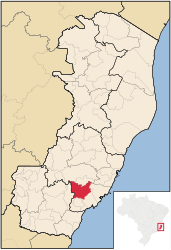
Alfredo Chaves è un comune del Brasile nello Stato dell'Espírito Santo, parte della mesoregione Central Espírito-Santense e della microregione di Guarapari.
| Alfredo Chaves comune | |||
|---|---|---|---|
| |||
| Localizzazione | |||
| Stato | |||
| Stato federato | |||
| Mesoregione | Central Espírito-Santense | ||
| Microregione | Guarapari | ||
| Amministrazione | |||
| Sindaco | Roberto Fortunato Fiorin | ||
| Territorio | |||
| Coordinate | 20°38′09″S 40°44′58″W | ||
| Altitudine | 19 e 576 m s.l.m. | ||
| Superficie | 615,791 km² | ||
| Abitanti | 13 955[1] (2010) | ||
| Densità | 22,66 ab./km² | ||
| Altre informazioni | |||
| Prefisso | 27 | ||
| Fuso orario | UTC-3 | ||
| Codice IBGE | 3200300 | ||
| Nome abitanti | alfredense | ||
| Cartografia | |||
 Alfredo Chaves | |||
 | |||

Note
- (PT) Scheda del comune dall'IBGE - Censimento 2010, su cidades.ibge.gov.br. URL consultato l'8 dicembre 2013 (archiviato dall'url originale il 14 dicembre 2013).
Altri progetti
 Wikimedia Commons contiene immagini o altri file su Alfredo Chaves
| Controllo di autorità | VIAF (EN) 305940183 · LCCN (EN) n2014205569 |
|---|
На других языках
[de] Alfredo Chaves
Alfredo Chaves, amtlich portugiesisch Município de Alfredo Chaves, ist eine brasilianische Kleinstadt im Bundesstaat Espírito Santo, etwa 60 km südwestlich von der Landeshauptstadt Vitória entfernt im Landesinneren. Alfredo Chaves hatte 13.955 Einwohner bei der Volkszählung 2010 und eine Fläche von 615,791 km².[2] Die Bevölkerung wurde zum 1. Juli 2021 auf 14.670 Einwohner geschätzt, die Alfredenser (portugiesisch alfredenses) genannt werden.[2][en] Alfredo Chaves
Alfredo Chaves is a municipality in the state of Espírito Santo, Brazil. It is 60 km southwest of the state capital, Vitória. Its population was 14,636 (2020) and its area is 615.79 km².[2][fr] Alfredo Chaves
Alfredo Chaves est une municipalité brésilienne située dans l'État de l'Espirito Santo.- [it] Alfredo Chaves
[ru] Алфреду-Шавис (Эспириту-Санту)
Алфреду-Шавис (порт. Alfredo Chaves) — муниципалитет в Бразилии, входит в штат Эспириту-Санту. Составная часть мезорегиона Центр штата Эспириту-Санту. Входит в экономико-статистический микрорегион Гуарапари. Население составляет 14 332 человека на 2006 год. Занимает площадь 615,593 км². Плотность населения — 23,3 чел./км².Текст в блоке "Читать" взят с сайта "Википедия" и доступен по лицензии Creative Commons Attribution-ShareAlike; в отдельных случаях могут действовать дополнительные условия.
Другой контент может иметь иную лицензию. Перед использованием материалов сайта WikiSort.org внимательно изучите правила лицензирования конкретных элементов наполнения сайта.
Другой контент может иметь иную лицензию. Перед использованием материалов сайта WikiSort.org внимательно изучите правила лицензирования конкретных элементов наполнения сайта.
2019-2026
WikiSort.org - проект по пересортировке и дополнению контента Википедии
WikiSort.org - проект по пересортировке и дополнению контента Википедии