world.wikisort.org - Brésil
Hortolândia est une commune brésilienne de l'État de São Paulo.
| Hortolândia Devise : Construindo uma vida melhor! | ||||
 Héraldique |
 Drapeau |
|||
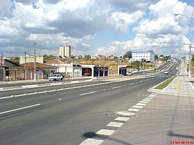
 Hortolândia : avenue Olívio Franceshini. | ||||
| Administration | ||||
|---|---|---|---|---|
| Pays | ||||
| Région | Sud-Est | |||
| État | ||||
| Langue(s) | portugais | |||
| Maire | Antônio Meira (PT) | |||
| Fuseau horaireHeure d'été | UTC-3UTC-4 | |||
| Indicatif | 19 | |||
| Démographie | ||||
| Gentilé | hortolandense | |||
| Population | 205 856 hab.[1] (04/2009) | |||
| Densité | 3 308 hab./km2 | |||
| Géographie | ||||
| Coordonnées | 22° 21′ 05″ sud, 47° 07′ 52″ ouest | |||
| Altitude | 587 m |
|||
| Superficie | 6 222,4 ha = 62,224 km2 | |||
| Divers | ||||
| Date de fondation | ||||
| Localisation | ||||
| Géolocalisation sur la carte : État de São Paulo
Géolocalisation sur la carte : Brésil
Géolocalisation sur la carte : Brésil
| ||||
| Liens | ||||
| Site web | Site officiel | |||
| modifier |
||||
Géographie
Hortolândia se trouve à 17 km à l'est-nord-est de Campinas, à 98 km au nord-ouest de São Paulo et à 789 km au sud de Brasília[2].
Son centre est situé à une altitude de 587 m, la zone urbanisée quant à elle étant située à une altitude variant entre 560 et 650 m. La municipalité s'étend sur 62,224 km2, dont 24,534 km2 en zone urbaine et 37,7 km2 en zone rurale.
Population
Sa population s'élevait à 192 692 habitants au recensement de 2010 et à 215 819 habitants en 2015 selon l'estimation de l'Institut brésilien de géographie et de statistiques.
Maires
Notes et références
- IBGE
- Distances à vol d'oiseau ou distances orthodromiques.
- Portail de l'État de São Paulo
На других языках
[de] Hortolândia
Hortolândia ist eine Gemeinde im Landesinneren des brasilianischen Bundesstaates São Paulo. Im Jahr 2018 lebten nach offizieller Schätzung etwa 227.400 Menschen in Hortolândia.[1][en] Hortolândia
Hortolândia is a Brazilian municipality in the interior of the state of São Paulo. It is part of the Metropolitan Region of Campinas[4] and the Mesoregion and Microregion of Campinas. It is located northwest of the state capital, about 110 km away. It is part of the São Paulo macrometropolis, which exceeds 29 million inhabitants and makes up approximately 75 percent of the state's population. The metropolitan regions of Campinas and São Paulo form the first megalopolis in the southern hemisphere.[5] It is bordered by Sumaré, to the north; Monte Mor, to the south and west; and Campinas, to the east.[6]- [fr] Hortolândia
[ru] Ортоландия
Ортоландия (порт. Hortolândia) — муниципалитет в Бразилии, входит в штат Сан-Паулу. Составная часть мезорегиона Кампинас. Находится в составе крупной городской агломерации Агломерация Кампинас. Входит в экономико-статистический микрорегион Кампинас. Население составляет 190 781 человек на 2007 год. Занимает площадь 62,224 км². Плотность населения — 3.243,0 чел./км².Текст в блоке "Читать" взят с сайта "Википедия" и доступен по лицензии Creative Commons Attribution-ShareAlike; в отдельных случаях могут действовать дополнительные условия.
Другой контент может иметь иную лицензию. Перед использованием материалов сайта WikiSort.org внимательно изучите правила лицензирования конкретных элементов наполнения сайта.
Другой контент может иметь иную лицензию. Перед использованием материалов сайта WikiSort.org внимательно изучите правила лицензирования конкретных элементов наполнения сайта.
2019-2025
WikiSort.org - проект по пересортировке и дополнению контента Википедии
WikiSort.org - проект по пересортировке и дополнению контента Википедии


