world.wikisort.org - L'Autriche
Alsergrund est le neuvième arrondissement de Vienne. Il englobe d'est en ouest les quartiers de Roßau, Alservorstad, Michelbeuern, Himmelpfortgrund, Thurygrund, Lichtental au centre, et Althangrund au nord.
| Alsergrund | ||||
 Héraldique |
||||
| Administration | ||||
|---|---|---|---|---|
| Pays | ||||
| Land | ||||
| Statut | Arrondissement | |||
| District (Bezirk) |
Vienne | |||
| Conseillers municipaux | 40 conseillers 13 SPÖ, 12 Grüne, 6 ÖVP, 6 FPÖ, 3 Neos |
|||
| Maire | Saya Ahmad (SPÖ) | |||
| Code postal | A-1090 | |||
| Immatriculation | W | |||
| Indicatif | +43 (0)1 | |||
| Démographie | ||||
| Population | 41 958 hab. (2019) | |||
| Densité | 14 033 hab./km2 | |||
| Géographie | ||||
| Coordonnées | 48° 13′ 31″ nord, 16° 21′ 25″ est | |||
| Altitude | 179 m |
|||
| Superficie | 299 ha = 2,99 km2 | |||
| Localisation | ||||
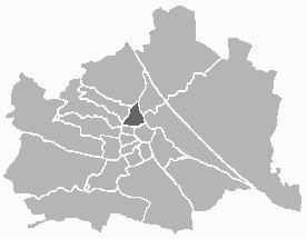 Localisation en Autriche | ||||
| Géolocalisation sur la carte : Vienne
Géolocalisation sur la carte : Autriche
Géolocalisation sur la carte : Autriche
| ||||
| Liens | ||||
| Site web | http://www.wien.gv.at/alsergrund Courriel | |||
| modifier |
||||


Lieux remarquables
- Le Palais Angerer
- Le Palais Chotek
Articles connexes
- Arrondissements de Vienne
- Communautés cadastrales de Vienne
 Portail de Vienne
На других языках
[en] Alsergrund
Alsergrund (German pronunciation: [ˈalzɐˌɡrʊnt] (listen); Central Bavarian: Oisagrund) is the ninth district of Vienna, Austria (German: 9. Bezirk, Alsergrund). It is located just north of the first, central district, Innere Stadt. Alsergrund was incorporated in 1862, with seven suburbs. As a central district, the area is densely populated. According to the census of 2001, there were 37,816 inhabitants over 2.99 square km (1.15 sq. mi).- [fr] Alsergrund
Текст в блоке "Читать" взят с сайта "Википедия" и доступен по лицензии Creative Commons Attribution-ShareAlike; в отдельных случаях могут действовать дополнительные условия.
Другой контент может иметь иную лицензию. Перед использованием материалов сайта WikiSort.org внимательно изучите правила лицензирования конкретных элементов наполнения сайта.
Другой контент может иметь иную лицензию. Перед использованием материалов сайта WikiSort.org внимательно изучите правила лицензирования конкретных элементов наполнения сайта.
2019-2026
WikiSort.org - проект по пересортировке и дополнению контента Википедии
WikiSort.org - проект по пересортировке и дополнению контента Википедии