world.wikisort.org - Australia
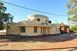
Narembeen è una città situata nella regione di Wheatbelt, in Australia Occidentale; essa si trova 290 chilometri a est di Perth ed è la sede della Contea di Narembeen. Al censimento del 2006 contava 469 abitanti.[1]
| Narembeen città | |
|---|---|
 | |
| Localizzazione | |
| Stato | |
| Stato federato | |
| Local government area | Contea di Narembeen |
| Territorio | |
| Coordinate | 32°03′47″S 118°23′46″E |
| Altitudine | 280 m s.l.m. |
| Abitanti | 469 (2006) |
| Altre informazioni | |
| Cod. postale | WA 6369 |
| Fuso orario | UTC+8 |
| Regione | Wheatbelt |
| Cartografia | |
Note
Altri progetti
 Wikimedia Commons contiene immagini o altri file su Narembeen
Collegamenti esterni
- (EN) Sito istituzionale della Contea di Narembeen, su narembeen.wa.gov.au.
На других языках
[en] Narembeen, Western Australia
Narembeen is a town in the Wheatbelt region of Western Australia. It is 286 km, almost due east, from Perth, the capital of WA. It is the major settlement in the Shire of Narembeen, in which the major industries are growing cereal crops and raising cattle and sheep. The surrounding areas produce wheat and other cereal crops. The town is a receival site for Cooperative Bulk Handling.[2]- [it] Narembeen
Текст в блоке "Читать" взят с сайта "Википедия" и доступен по лицензии Creative Commons Attribution-ShareAlike; в отдельных случаях могут действовать дополнительные условия.
Другой контент может иметь иную лицензию. Перед использованием материалов сайта WikiSort.org внимательно изучите правила лицензирования конкретных элементов наполнения сайта.
Другой контент может иметь иную лицензию. Перед использованием материалов сайта WikiSort.org внимательно изучите правила лицензирования конкретных элементов наполнения сайта.
2019-2025
WikiSort.org - проект по пересортировке и дополнению контента Википедии
WikiSort.org - проект по пересортировке и дополнению контента Википедии
