world.wikisort.org - Australia
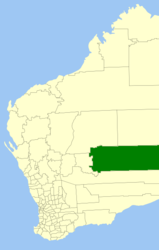
La contea di Laverton è una delle nove Local Government Areas che si trovano nella regione di Goldfields-Esperance, in Australia Occidentale. Essa si estende su di una superficie di circa 179.797 chilometri quadrati ed ha una popolazione di circa 730 abitanti.
| Contea di Laverton local government area | |
|---|---|
| Shire of Laverton | |
| Localizzazione | |
| Stato | |
| Stato federato | |
| Amministrazione | |
| Capoluogo | Laverton |
| Territorio | |
| Coordinate del capoluogo | 28°37′48″S 122°24′36″E |
| Altitudine | 381 m s.l.m. |
| Superficie | 179 797 km² |
| Abitanti | 1 153 (2016) |
| Densità | 0,01 ab./km² |
| Altre informazioni | |
| Fuso orario | UTC+8 |
| Regione | Goldfields-Esperance |
| Cartografia | |
 | |
| Sito istituzionale | |

Altri progetti
 Wikimedia Commons contiene immagini o altri file su contea di Laverton
Collegamenti esterni
- (EN) Sito ufficiale della contea di Laverton, su laverton.wa.gov.au. URL consultato il 18 luglio 2008 (archiviato dall'url originale il 18 luglio 2008).
| Controllo di autorità | ISNI (EN) 0000 0004 0418 1793 |
|---|
На других языках
[de] Laverton Shire
-28.616666666667122.4 Das Shire of Laverton ist ein lokales Verwaltungsgebiet (LGA) im australischen Bundesstaat Western Australia. Das Gebiet ist 179.798 km² groß und hat etwa 1150 Einwohner (2016).[en] Shire of Laverton
The Shire of Laverton is a local government area in the Goldfields-Esperance region of Western Australia, about 370 kilometres (230 mi) northeast of the city of Kalgoorlie and about 950 kilometres (590 mi) east-northeast of the state capital, Perth. The Shire covers an area of 179,798 square kilometres (69,420 sq mi), and its seat of government is the town of Laverton.- [it] Contea di Laverton
Текст в блоке "Читать" взят с сайта "Википедия" и доступен по лицензии Creative Commons Attribution-ShareAlike; в отдельных случаях могут действовать дополнительные условия.
Другой контент может иметь иную лицензию. Перед использованием материалов сайта WikiSort.org внимательно изучите правила лицензирования конкретных элементов наполнения сайта.
Другой контент может иметь иную лицензию. Перед использованием материалов сайта WikiSort.org внимательно изучите правила лицензирования конкретных элементов наполнения сайта.
2019-2026
WikiSort.org - проект по пересортировке и дополнению контента Википедии
WikiSort.org - проект по пересортировке и дополнению контента Википедии