world.wikisort.org - Australia
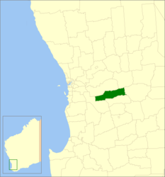
La contea di Brookton è una delle 43 local government areas che si trovano nella regione di Wheatbelt, in Australia Occidentale. Si estende su di una superficie di circa 1.602 chilometri quadrati ed ha una popolazione di 978 abitanti. L'economia locale si basa fondamentalmente sull'allevamento delle pecore e sull'agricoltura, principalmente con coltivazioni di grano.
| Contea di Brookton local government area | |
|---|---|
| Shire of Brookton | |
| Localizzazione | |
| Stato | |
| Stato federato | |
| Amministrazione | |
| Capoluogo | Brookton |
| Territorio | |
| Coordinate del capoluogo | 33°22′05″S 117°00′22″E |
| Altitudine | 237 m s.l.m. |
| Superficie | 1 602 km² |
| Abitanti | 978 (2006) |
| Densità | 0,61 ab./km² |
| Altre informazioni | |
| Fuso orario | UTC+8 |
| Regione | Wheatbelt |
| Cartografia | |
 | |
| Sito istituzionale | |

Altri progetti
 Wikimedia Commons contiene immagini o altri file su contea di Brookton
Collegamenti esterni
- (EN) Sito ufficiale, su brookton.wa.gov.au.
| Controllo di autorità | ISNI (EN) 0000 0004 0415 3530 |
|---|
На других языках
[de] Brookton Shire
-32.366666666667117 Das Shire of Brookton ist ein lokales Verwaltungsgebiet (LGA) im australischen Bundesstaat Western Australia. Das Gebiet ist 1602 km² groß und hat 975 Einwohner (2016).[en] Shire of Brookton
The Shire of Brookton is a local government area in the Wheatbelt region of Western Australia, about 140 kilometres (87 mi) southeast of Perth, the state capital. The Shire covers an area of 1,602 square kilometres (619 sq mi) and its seat of government is the town of Brookton.- [it] Contea di Brookton
Текст в блоке "Читать" взят с сайта "Википедия" и доступен по лицензии Creative Commons Attribution-ShareAlike; в отдельных случаях могут действовать дополнительные условия.
Другой контент может иметь иную лицензию. Перед использованием материалов сайта WikiSort.org внимательно изучите правила лицензирования конкретных элементов наполнения сайта.
Другой контент может иметь иную лицензию. Перед использованием материалов сайта WikiSort.org внимательно изучите правила лицензирования конкретных элементов наполнения сайта.
2019-2026
WikiSort.org - проект по пересортировке и дополнению контента Википедии
WikiSort.org - проект по пересортировке и дополнению контента Википедии