world.wikisort.org - Australia
Seal Rocks is a small coastal settlement in the Mid-Coast Council local government area, in the Mid North Coast region of New South Wales, Australia, 275 kilometres (171 mi) north-north-east of Sydney.[2][6] It is famous for its many premier surfing beaches (including Lighthouse Beach, Treachery and Yagon), and also for being the home of Seal Rocks lighthouse, officially known as Sugarloaf Point Lighthouse. At the 2006 census, the area had a population of 131 persons.[1]
| Seal Rocks New South Wales | |||||||||||||||
|---|---|---|---|---|---|---|---|---|---|---|---|---|---|---|---|
 Seal Rocks beach | |||||||||||||||
Seal Rocks | |||||||||||||||
| Coordinates | 32°25′13″S 152°30′27″E | ||||||||||||||
| Population | 131 (2006)[1] Note1 | ||||||||||||||
| Postcode(s) | 2423 | ||||||||||||||
| Time zone | AEST (UTC+10) | ||||||||||||||
| • Summer (DST) | AEDT (UTC+11) | ||||||||||||||
| Location | |||||||||||||||
| LGA(s) | Mid-Coast Council[2] | ||||||||||||||
| Region | Mid North Coast[2] | ||||||||||||||
| County | Gloucester[3] | ||||||||||||||
| Parish | Forster[3] | ||||||||||||||
| State electorate(s) | Myall Lakes[4] | ||||||||||||||
| Federal division(s) | Lyne[5] | ||||||||||||||
| |||||||||||||||
History
Prior to European settlement, the area that is now Seal Rocks was occupied by the Worimi Aboriginal people
On 2 June 1864, the Rainbow was wrecked on Seal Rocks.[7]
The Sugarloaf Point Light was installed and lit on 1 December 1875. In 1923, the lighthouse converted from kerosene to acetylene gas. The lighthouse was electrified in June 1966. By 1987, the lighthouse had been automated and no longer required staffed keepers.
In 1895 the SS Catterthun, heading for China from Sydney, was wrecked on the rocks and 54 (31?) passengers and crew drowned.
Heritage listings
Seal Rocks has a number of heritage-listed sites, including:
- Seal Rocks Road, Myall Lakes National Park: Sugarloaf Point Light[8]
Resistance to commercialisation
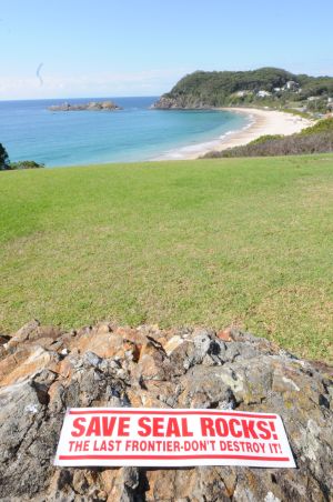
Seal Rocks is well known for its peaceful resistance to attempts by developers to commercialise the small picturesque fishing village. On entering the town by the road, the slogan "Save Seal Rocks The Last Frontier" can be seen painted on the road itself, this has been continually repainted for over 30 years. Currently the local council is making an attempt to commercialise the small caravan park, and a movement is once again growing against this.[9]
The 2013 movie Adore was filmed at this location.
Seal colony
Seal Rocks was named after the Australian fur seals that were often seen on the rocks near the Sugarloaf Point Lighthouse. There is some evidence that a breeding colony of seals once existed at Seal Rocks, although the species no longer breeds in NSW and the colony was lost.[10] However, more recently sightings have been increasing in the Port Stephens area.[11]
Sugarloaf Point Lighthouse
The construction of Sugarloaf Lighthouse was completed in 1875, ten years after it was recommended a light be placed to highlight the treacherous Seal Rocks. It was originally intended to place the light on Seal Rocks but landing was difficult and so the proposition was abandoned.
The tower is constructed of brick, rendered and painted white. Also constructed were three adjoining cottages, various outbuildings, the construction of the road from Bungwahl, and a 460-metre (1,509 ft) long jetty which was used to land some 1,829 tonnes (1,800 long tons) of building supplies and materials.
The light was upgraded in 1923 and was converted from kerosene to acetylene gas. Electricity was introduced in 1966 and the light was kept staffed for many years despite automation in 1987.
The Sugarloaf lighthouse is the second-most easterly one in Australia, after the Byron Bay lighthouse, and offers accommodation in three cottages.[12]
One of Australia's biggest shipping disasters occurred off Sugarloaf Point; the wreck of the SS Catterthun in 1895 when bound from Sydney to China with the loss of thirty one lives. Although some reports state that 54 persons lost their lives, the NSW marine board of inquiry listed 31 as the correct number.
References
- Australian Bureau of Statistics (25 October 2007). "Seal Rocks (State Suburb)". 2006 Census QuickStats. Retrieved 22 February 2010. Map
- "Suburb Search - Local Council Boundaries - Hunter (HT) - Great Lakes Council". New South Wales Division of Local Government. Archived from the original on 16 January 2013. Retrieved 22 February 2010.
- "Seal Rocks". Geographical Names Register (GNR) of NSW. Geographical Names Board of New South Wales. Retrieved 22 February 2010.
- "Myall Lakes". New South Wales Electoral Commission. Retrieved 23 November 2019.
- "Paterson". Australian Electoral Commission. 19 October 2007. Archived from the original on 29 October 2009. Retrieved 22 February 2010.
- "Seal Rocks". Land and Property Management Authority - Spatial Information eXchange. New South Wales Land and Property Information. Retrieved 22 February 2010.
- "Rainbow PS". Office of Environment and Heritage. State Government of NSW. Retrieved 24 April 2022.
- "Sugarloaf Point Lightstation Group". New South Wales State Heritage Register. Office of Environment & Heritage. H02025. Retrieved 18 February 2020.
- Seal Rocks fights for serenity, The Sydney Morning Herald, 10 May 2010
- "Australian fur-seal - vulnerable species listing". NSW Office of Environment & Heritage. 27 February 2011. Retrieved 8 April 2012.
- David Harasti. "Fur-Seals". Wild about whales blog. National Parks and Wildlife Service (New South Wales). Retrieved 8 April 2012.
- Australia’s iconic lighthouses, Australian Geographic, 26 July 2010
External links
На других языках
- [en] Seal Rocks, New South Wales
[ru] Сил-Рокс
Сил-Рокс — это небольшое прибрежное поселение в районе местного самоуправления Совета Среднего побережья (Mid-Coast Council) Среднего Северного побережья Нового Южного Уэльса, Австралия, в 275 км к северо-северо-востоку от Сиднея. Известно многочисленными первоклассными пляжами для серфинга (включая Lighthouse Beach, Treachery и Yagon), а также тем, что здесь находится маяк Seal Rocks, официально известный как Sugarloaf Point Lighthouse. По переписи 2006 года в районе проживал 131 человек.Другой контент может иметь иную лицензию. Перед использованием материалов сайта WikiSort.org внимательно изучите правила лицензирования конкретных элементов наполнения сайта.
WikiSort.org - проект по пересортировке и дополнению контента Википедии