world.wikisort.org - Australia
Minto Parish is one of the 57 parishes of Cumberland County, New South Wales, a cadastral unit for use on land titles. It includes Minto, Ingleburn, Glenfield and Macquarie Fields. Its eastern boundary is the Georges River, and western boundary was at the Great Southern Road.
 Map from the 1840s of the Hundred of Liverpool in western Sydney, Australia.

| Minto New South Wales | |||||||||||||||
|---|---|---|---|---|---|---|---|---|---|---|---|---|---|---|---|
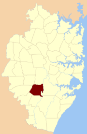 Location of the parish within Cumberland | |||||||||||||||
| Established | 1835 | ||||||||||||||
| LGA(s) | City of Campbelltown | ||||||||||||||
| County | Cumberland | ||||||||||||||
| Hundred (former) | Liverpool | ||||||||||||||
| |||||||||||||||
References
- "Minto Parish". Geographical Names Register (GNR) of NSW. Geographical Names Board of New South Wales.
This article related to the geography of Sydney is a stub. You can help Wikipedia by expanding it. |
Текст в блоке "Читать" взят с сайта "Википедия" и доступен по лицензии Creative Commons Attribution-ShareAlike; в отдельных случаях могут действовать дополнительные условия.
Другой контент может иметь иную лицензию. Перед использованием материалов сайта WikiSort.org внимательно изучите правила лицензирования конкретных элементов наполнения сайта.
Другой контент может иметь иную лицензию. Перед использованием материалов сайта WikiSort.org внимательно изучите правила лицензирования конкретных элементов наполнения сайта.
2019-2025
WikiSort.org - проект по пересортировке и дополнению контента Википедии
WikiSort.org - проект по пересортировке и дополнению контента Википедии