world.wikisort.org - Australia
Nuytsland Nature Reserve is a protected area of Western Australia in the south-eastern part of the state, on the south coast.
| Nuytsland Nature Reserve Western Australia | |
|---|---|
IUCN category Ia (strict nature reserve) | |
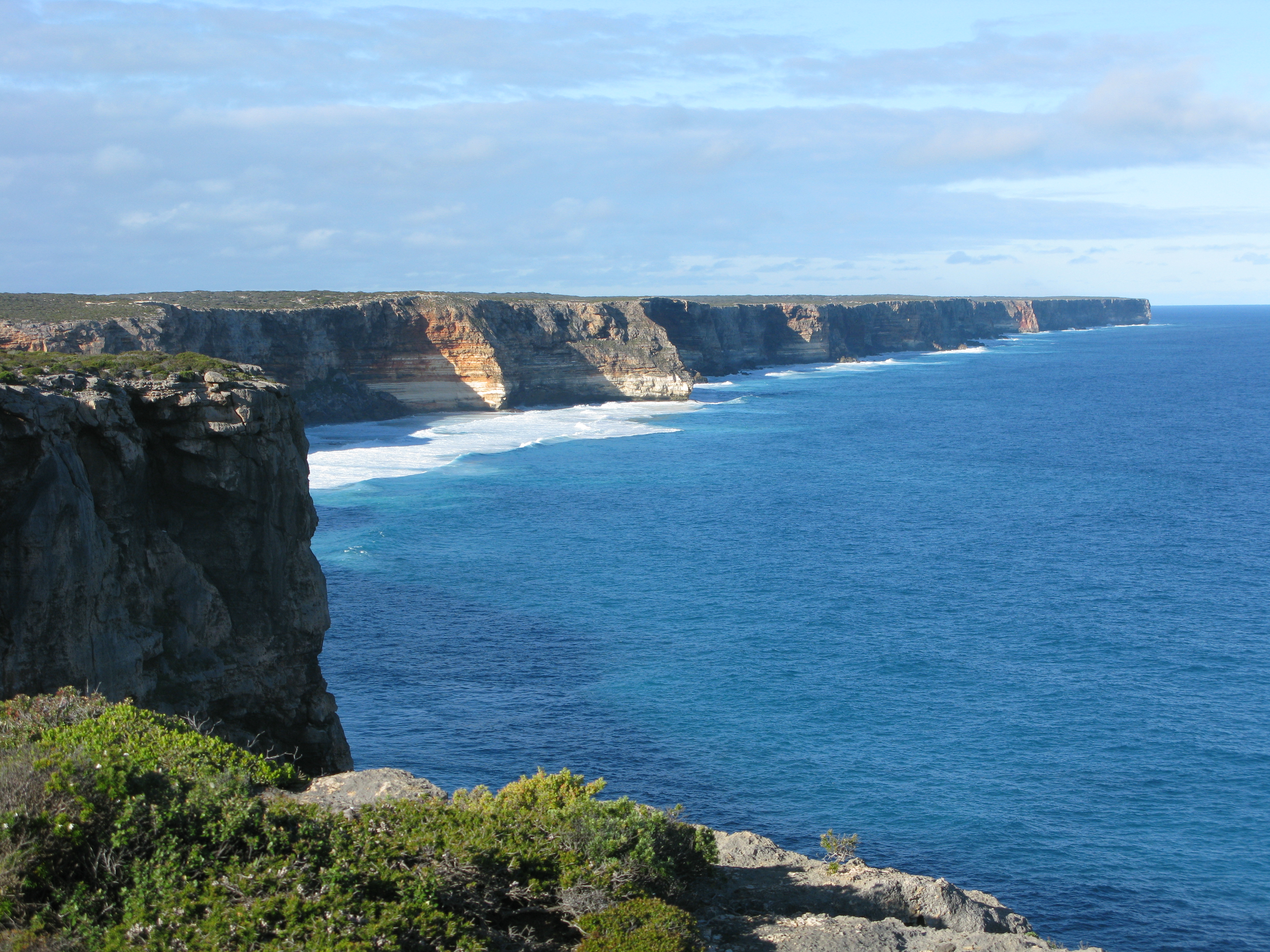 The Great Australian Bight and Baxter Cliffs at Toolinna Cove, Nuytsland Nature Reserve, 2010 | |
 Nuytsland Nature Reserve | |
| Nearest town or city | Esperance |
| Coordinates | 32°18′0″S 125°52′0″E |
| Established | 1969 |
| Area | 6,253.44 km2 (2,414.5 sq mi) |
| Managing authorities | Parks and Wildlife Service, Government of Western Australia |
| See also | List of protected areas of Western Australia |
Geography
Nominally located at 32° 18' S 125° 52' E, it has an area of 6,253.44 km², and takes in over 500 kilometres of coastline from Cape Pasley to Red Rocks Point.[1]
In the southwest the reserve includes the Israelite Plain, a coastal plain with broad beaches, dunes, sandplains, and coastal lagoons which includes Israelite Bay. The middle section of the reserve protects the Baxter Cliffs, dramatic seacliffs that extend up to 80 metres high for over 190 km along the coast. The Baxter Cliffs feature Toolinna Cove and Twilight Cove. The reserve boundary extends northwards near Cocklebiddy to encompass Cocklebiddy Cave on the Hampton Tableland. The eastern end of the reserve includes the western portion of the Roe Plains, with extensive coastal dunes and sandplains. Eyre Bird Observatory is located near Cocklebiddy, where the cliffs transition to the Roe Plains.[2][3][4]
At the reserve's western end it adjoins Cape Arid National Park. Ngadju Indigenous Protected Area bounds the western portion of the reserve on the north.
Flora and fauna
Plant communities include heath on the western coastal plains and headlands, woodlands and mallee dominated by eucalypts, and bluebush (Maireana spp.) shrublands in the east.[2]
The reserve has been surveyed for the western ground parrot (Pezoporus flaviventris).[5]
Conservation
The reserve was gazetted in 1969. It lies within the Nuyts cadastral division of the state.
Climate
| Climate data for Eyre (6m elevation) 1991–2020 | |||||||||||||
|---|---|---|---|---|---|---|---|---|---|---|---|---|---|
| Month | Jan | Feb | Mar | Apr | May | Jun | Jul | Aug | Sep | Oct | Nov | Dec | Year |
| Average high °C (°F) | 27.5 (81.5) |
27.1 (80.8) |
26.3 (79.3) |
25.0 (77.0) |
22.1 (71.8) |
19.7 (67.5) |
19.1 (66.4) |
20.4 (68.7) |
22.2 (72.0) |
24.3 (75.7) |
25.4 (77.7) |
26.7 (80.1) |
23.8 (74.8) |
| Average low °C (°F) | 15.2 (59.4) |
15.9 (60.6) |
14.0 (57.2) |
11.3 (52.3) |
8.3 (46.9) |
6.0 (42.8) |
5.0 (41.0) |
5.5 (41.9) |
7.3 (45.1) |
9.9 (49.8) |
11.9 (53.4) |
14.0 (57.2) |
10.4 (50.7) |
| Average rainfall mm (inches) | 27.1 (1.07) |
34.2 (1.35) |
31.5 (1.24) |
29.4 (1.16) |
31.4 (1.24) |
34.6 (1.36) |
36.5 (1.44) |
30.2 (1.19) |
28.0 (1.10) |
22.1 (0.87) |
27.6 (1.09) |
29.0 (1.14) |
361.2 (14.22) |
| Average rainy days | 5.6 | 6.2 | 8.0 | 8.5 | 10.5 | 10.5 | 11.0 | 10.3 | 9.1 | 7.8 | 7.5 | 6.2 | 101.2 |
| Source: bom.gov.au[6] | |||||||||||||
References
- Western Australia. Dept. of Conservation and Land Management (2010), Cape Arid and Eucla National Parks, Israelite Bay, Dept. of Conservation & Land Management, retrieved 2 March 2017
- Nuytsland Nature Reserve. Parks and Wildlife Service, Government of Western Australia. Accessed 12 May 2022.
- Harris, Alex (2 March 1979), "Life in the most remote bird observatory", West Australian (2 Mar 1979): 7, 10, retrieved 2 March 2017
- Riley, Kathy (1 January 2007), "Nature in the raw.(Nuytsland Nature Reserve)(Geographic overview)", Australian Geographic, Athena Information Solutions Pvt. Ltd (85): 94–99, ISSN 0816-1658
- Newbey, Brenda; Chemello, David; Barth, Michael (2006), Search for the western ground parrot in Nuytsland Nature Reserve and Cape Arid National Park, 2005-2006, Birds Australia, Western Australia, retrieved 2 March 2017
- "Climate Normals 1991–2020". BOM. Retrieved 23 February 2021.
External link
- Nuytsland Nature Reserve, Parks and Wildlife Service, Government of Western Australia
Другой контент может иметь иную лицензию. Перед использованием материалов сайта WikiSort.org внимательно изучите правила лицензирования конкретных элементов наполнения сайта.
WikiSort.org - проект по пересортировке и дополнению контента Википедии