world.wikisort.org - Australia
Napperby is a locality in the Mid North of South Australia in the approach to the lower Flinders Ranges and is near Mount Remarkable National Park and the town of Crystal Brook.
| Napperby South Australia | |||||||||||||||
|---|---|---|---|---|---|---|---|---|---|---|---|---|---|---|---|
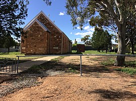 Former Methodist and Uniting Church | |||||||||||||||
 Napperby | |||||||||||||||
| Coordinates | 33°09′20″S 138°07′03″E[1] | ||||||||||||||
| Population | 666 (SAL 2021)[2] | ||||||||||||||
| Established | 29 March 1877 (town) 29 June 1995 (locality)[1] | ||||||||||||||
| Time zone | ACST (UTC+9:30) | ||||||||||||||
| • Summer (DST) | ACST (UTC+10:30) | ||||||||||||||
| Location | 12 km (7 mi) northeast of Port Pirie | ||||||||||||||
| LGA(s) | Port Pirie Regional Council[1] | ||||||||||||||
| Region | Yorke and Mid North[1] | ||||||||||||||
| County | Victoria[1] | ||||||||||||||
| State electorate(s) | Frome[3] | ||||||||||||||
| Federal division(s) | Grey[4] | ||||||||||||||
| |||||||||||||||
| Footnotes | Adjoining localities[1] | ||||||||||||||
The 2016 Australian census which was conducted in August 2016 reports that Napperby had a population of 665 of which 284 lived in its town centre.[5][6]
Napperby is located within the federal division of Grey, the state electoral district of Frome and the local government area of the Port Pirie Regional Council.[4][3][1]
References
- "Search results for 'Napperby, LOCB' with the following datasets being selected - 'Suburbs and Localities', "Government Towns', 'Counties', 'Local Government Areas', 'SA Government Regions' and 'Gazetteer'". Location SA Map Viewer. Government of South Australia. Retrieved 1 May 2018.
- Australian Bureau of Statistics (28 June 2022). "Napperby (Suburb and Locality)". Australian Census 2021 QuickStats. Retrieved 28 June 2022.
- "Electoral district of Frome". Electoral Commission SA. Retrieved 12 February 2018.
- "Federal electoral division of Grey" (PDF). Australian Electoral Commission. Retrieved 12 February 2018.
- Australian Bureau of Statistics (27 June 2017). "Napperby (locality)". 2016 Census QuickStats. Retrieved 1 May 2018.
- Australian Bureau of Statistics (27 June 2017). "Napperby (Urban centre)". 2016 Census QuickStats. Retrieved 1 May 2018.
Текст в блоке "Читать" взят с сайта "Википедия" и доступен по лицензии Creative Commons Attribution-ShareAlike; в отдельных случаях могут действовать дополнительные условия.
Другой контент может иметь иную лицензию. Перед использованием материалов сайта WikiSort.org внимательно изучите правила лицензирования конкретных элементов наполнения сайта.
Другой контент может иметь иную лицензию. Перед использованием материалов сайта WikiSort.org внимательно изучите правила лицензирования конкретных элементов наполнения сайта.
2019-2026
WikiSort.org - проект по пересортировке и дополнению контента Википедии
WikiSort.org - проект по пересортировке и дополнению контента Википедии