world.wikisort.org - Australia
Murray Bridge North is a semi-rural satellite locality of Murray Bridge in South Australia east of the Murray River and northwest of the eponymous bridge.[2] Its boundaries were formalised in March 2000 to cover a portion of land on either side of the main road to Mannum north of the main conurbation of Murray Bridge and west of the riverside industries of Mobilong and Toora.[2]
| Murray Bridge North South Australia | |||||||||||||||
|---|---|---|---|---|---|---|---|---|---|---|---|---|---|---|---|
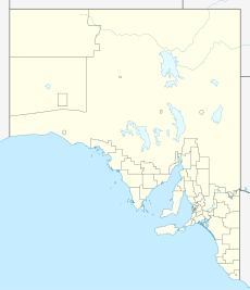  Murray Bridge North | |||||||||||||||
| Coordinates | 35.075°S 139.270°E | ||||||||||||||
| Population | 142 (SAL 2021)[1] | ||||||||||||||
| Postcode(s) | 5253 | ||||||||||||||
| LGA(s) | Rural City of Murray Bridge | ||||||||||||||
| State electorate(s) | Hammond | ||||||||||||||
| Federal division(s) | Barker | ||||||||||||||
| |||||||||||||||
| Footnotes | Coordinates[2] | ||||||||||||||
See also
- List of cities and towns in South Australia
References
- Australian Bureau of Statistics (28 June 2022). "Murray Bridge North (Suburb and Locality)". Australian Census 2021 QuickStats. Retrieved 28 June 2022.
- "Placename Details: Murray Bridge North (Locality Bounded)". Property Location Browser. Government of South Australia. 11 July 2006. SA0044851. Retrieved 22 September 2017.

 | This South Australia geography article is a stub. You can help Wikipedia by expanding it. |
Текст в блоке "Читать" взят с сайта "Википедия" и доступен по лицензии Creative Commons Attribution-ShareAlike; в отдельных случаях могут действовать дополнительные условия.
Другой контент может иметь иную лицензию. Перед использованием материалов сайта WikiSort.org внимательно изучите правила лицензирования конкретных элементов наполнения сайта.
Другой контент может иметь иную лицензию. Перед использованием материалов сайта WikiSort.org внимательно изучите правила лицензирования конкретных элементов наполнения сайта.
2019-2026
WikiSort.org - проект по пересортировке и дополнению контента Википедии
WikiSort.org - проект по пересортировке и дополнению контента Википедии