world.wikisort.org - Australia
Lilli Pilli is a small suburb in southern Sydney, in the state of New South Wales, Australia. Lilli Pilli is located 26 kilometres south of the Sydney central business district, in the local government area of the Sutherland Shire. There is also another Lilli Pilli in New South Wales (postcode 2536), located 12 kilometres south of Batemans Bay.
| Lilli Pilli Sydney, New South Wales | |||||||||||||||
|---|---|---|---|---|---|---|---|---|---|---|---|---|---|---|---|
 Lilli Pilli Point | |||||||||||||||
Lilli Pilli | |||||||||||||||
| Coordinates | 34°04′06″S 151°06′57″E | ||||||||||||||
| Population | 1,390 (2016 census)[1] | ||||||||||||||
| • Density | 1,540/km2 (4,000/sq mi) | ||||||||||||||
| Postcode(s) | 2229 | ||||||||||||||
| Elevation | 35 m (115 ft) | ||||||||||||||
| Area | 0.9 km2 (0.3 sq mi) | ||||||||||||||
| Location | 26 km (16 mi) south of Sydney CBD | ||||||||||||||
| LGA(s) | Sutherland Shire | ||||||||||||||
| State electorate(s) | Cronulla | ||||||||||||||
| Federal division(s) | Cook | ||||||||||||||
| |||||||||||||||


History
Lilli Pilli was named for the lilly pilly, the native myrtle that grew on the point. Thomas Holt (1811–88) owned most of the land that stretched from Sutherland to Cronulla, including land on the point. In 1840, parish maps also showed that 20 acres (8.1 ha) of land on the point were owned by Francis Mitchell. The public school opened in 1957, and celebrated its 50th anniversary in 2007.[2]
Geography
This section does not cite any sources. (September 2022) |
Lilli Pilli is located on the north shore of the Port Hacking estuary. The only adjacent suburbs are Caringbah South, Port Hacking and Dolans Bay. The villages of Maianbar and Bundeena are located on the opposite bank of Port Hacking.
Lilli Pilli is surrounded by Gannons Bay, Little Turriel Bay, Port Hacking River and Great Turriel Bay. Lilli Pilli Point is situated at the end of Lilli Pilli Point Road, off Port Hacking Road. Lilli Pilli Point Bushland Reserve overlooks Royal National Park. This bushland reserve is a great secluded picnic area that is often protected from the wind. A rock ledge runs along the northern point up to Speed Alley. Many fishing spots can be found here, all the way to Little Turriell Bay.
Transport
Transdev NSW operates bus route 977 from Lilli Pilli Point to Caringbah and Miranda.[3]
Schools
- Lilli Pilli Primary School is on Lilli Pilli Point Road.
- Lilli Pilli Kindergarten is located nearby in Caringbah. The school has many sporting achievements, including the winning of the PSSA Soccer Division One Cup in 2008.[4]
Sport and recreation
Lilli Pilli is home to the Lilli Pilli Football Club.[5] Their homeground is Lilli Pilli Oval but other fields are also used such as Caringbah Oval, Solander Fields, Captain Cook Oval and Breen Park. Lilli Pilli is also home to 1st Lilli Pilli Sea Scouts.
In 2019, upgrades commenced to Lilli Pilli Oval's facilities, including an upgraded playing surface and clubhouse[6]
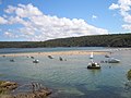 Port Hacking estuary at Lilli Pilli
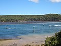 Port Hacking estuary at Lilli Pilli
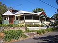 house on Lilli Pilli Point


References
- Australian Bureau of Statistics (27 June 2017). "Lilli Pilli (State Suburb)". 2016 Census QuickStats. Retrieved 9 November 2017.
- The Book of Sydney Suburbs, Compiled by Frances Pollon, Angus & Robertson Publishers, 1990, Published in Australia ISBN 0-207-14495-8, p51
- "Transdev NSW route 977". Transport for NSW.
- Lilli Pilli Primary School
- Lilli Pilli Football Club
- "New Lilli Pilli Oval clubhouse officially opened". St George & Sutherland Shire Leader. 19 August 2019. Retrieved 24 February 2022.
External links
Другой контент может иметь иную лицензию. Перед использованием материалов сайта WikiSort.org внимательно изучите правила лицензирования конкретных элементов наполнения сайта.
WikiSort.org - проект по пересортировке и дополнению контента Википедии