world.wikisort.org - Australia
Hanson (formerly Davies[4]) is a town in South Australia, located 29 kilometres (18 mi) north-east of Clare and 13 kilometres (8.1 mi) south-west of Burra at the intersection of the Barrier Highway and the Hanson-Farrell Flat Road in the Regional Council of Goyder. It is also adjacent to the former Peterborough railway line as the next station towards Adelaide from Burra which was the terminus for some time.
| Hanson South Australia | |||||||||||||||
|---|---|---|---|---|---|---|---|---|---|---|---|---|---|---|---|
 Hanson | |||||||||||||||
| Coordinates | 33°45′12″S 138°50′25″E[1] | ||||||||||||||
| Population | 19 (2016 census)[2] | ||||||||||||||
| Postcode(s) | 5417 | ||||||||||||||
| Time zone | ACST (UTC+9:30) | ||||||||||||||
| • Summer (DST) | ACST (UTC+10:30) | ||||||||||||||
| Location |
| ||||||||||||||
| LGA(s) | Regional Council of Goyder[1] | ||||||||||||||
| Region | Yorke and Mid North[1] | ||||||||||||||
| County | Stanley[1] | ||||||||||||||
| State electorate(s) | Stuart | ||||||||||||||
| Federal division(s) | Grey | ||||||||||||||
| |||||||||||||||
| |||||||||||||||
The 2016 Australian census which was conducted in August 2016 reports that Hanson had a population of 19 people.[2]
History
The town was surveyed in 1865 [5] and originally known as Daviestown, Davieston, or Davies Town, named after Sir Richard Davies Hanson (1805–76), a Chief Justice of South Australia and acting Governor of the then colony from 1872 to 1873.[6] The first lots were offered for sale first on 30 November 1865.[4] A decision was made around 1890 to rename the town Hanson, although the name was not officially changed until 19 September 1940.[7] The change brought the town's name into line with that of the nearby Hanson railway station.[6] On the same date, the nearby town known as Hanson officially became Farrell Flat, also aligning that town's name with that of its railway station.[6]
Over the years Hanson has comprised a church, a hall, a school, a shop, a railway station and a few houses.[6]
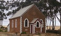 Former Hanson Methodist Church (2013)
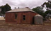 Former Hanson Primary School building (2013)


References
- "Search results for 'Hanson, LOCB' with the following datasets selected - 'Suburbs and localities', 'Counties', 'Government Towns', 'Local Government Areas', 'SA Government Regions' and 'Gazetteer'". Location SA Map Viewer. South Australian Government. Retrieved 28 December 2018.
- Australian Bureau of Statistics (27 June 2017). "Hanson (State Suburb)". 2016 Census QuickStats. Retrieved 28 December 2018.
- "Monthly climate statistics: Summary statistics Clare High School (nearest weather station)". Commonwealth of Australia , Bureau of Meteorology. Retrieved 28 December 2018.
- South Australian Names.
- The churches, www.burrahistory.info Retrieved on 8 November 2014
- Towns and other places in the District, www.burrahistory.info Retrieved on 8 November 2014
- "NEW TOWN NAMES APPROVED". The Advertiser (Adelaide). South Australia. 26 July 1940. p. 10. Retrieved 5 September 2016 – via National Library of Australia.
This South Australia geography article is a stub. You can help Wikipedia by expanding it. |
Другой контент может иметь иную лицензию. Перед использованием материалов сайта WikiSort.org внимательно изучите правила лицензирования конкретных элементов наполнения сайта.
WikiSort.org - проект по пересортировке и дополнению контента Википедии