world.wikisort.org - Australia
Gloucester County was one of the original Nineteen Counties in New South Wales, and is now one of the 141 cadastral divisions of New South Wales. It includes the area around Port Stephens. It is bounded on the north and west by the Manning River, and on the south-west by the Williams River.
| Gloucester New South Wales | |||||||||||||||
|---|---|---|---|---|---|---|---|---|---|---|---|---|---|---|---|
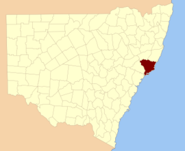 Location in New South Wales | |||||||||||||||
| |||||||||||||||
Overview
Gloucester County was named after County Gloucester, England.[1]
Parishes within this county
A full list of parishes found within this county, their current LGA and mapping coordinates to the approximate centre of each location is as follows:
| Parish | LGA | Coordinates |
|---|---|---|
| Alfred | Dungog Shire | 32°13′54″S 151°45′04″E |
| Avon | Mid-Coast Council | 32°06′54″S 151°58′04″E |
| Bachelor | Mid-Coast Council | 32°12′54″S 152°32′04″E |
| Barrington | Mid-Coast Council | 31°58′54″S 151°44′04″E |
| Beean Beean | Mid-Coast Council | 31°59′54″S 151°30′04″E |
| Belbora | Mid-Coast Council | 31°59′54″S 152°11′04″E |
| Berrico | Mid-Coast Council | 32°05′54″S 151°47′04″E |
| Beryan | Mid-Coast Council | 32°01′54″S 152°30′04″E |
| Bindera | Mid-Coast Council | 31°57′54″S 151°48′04″E |
| Blackcamp | Dungog Shire | 32°26′54″S 151°52′24″E |
| Bohnock | Mid-Coast Council | 31°57′54″S 152°32′04″E |
| Boolambayte | Mid-Coast Council | 32°19′54″S 152°14′04″E |
| Booral | Mid-Coast Council | 32°27′54″S 151°58′17″E |
| Bootawa | Mid-Coast Council | 31°56′54″S 152°19′04″E |
| Boranel | Mid-Coast Council | 31°55′54″S 151°40′04″E |
| Bulahdelah | Mid-Coast Council | 32°24′54″S 152°15′04″E |
| Carrington | Mid-Coast Council | 32°37′24″S 152°00′04″E |
| Coolongolook | Mid-Coast Council | 32°11′54″S 152°08′04″E |
| Coweambah | Mid-Coast Council | 32°39′01″S 152°06′46″E |
| Craven | Mid-Coast Council | 31°45′54″S 151°48′04″E |
| Crosbie | Mid-Coast Council | 31°53′54″S 151°53′04″E |
| Curreeki | Mid-Coast Council | 32°10′54″S 152°13′04″E |
| East Seaham | Port Stephens Council | 32°39′54″S 151°45′04″E |
| Eldon | Port Stephens Council | 32°43′54″S 151°45′04″E |
| Eurunderee | Mid-Coast Council | 32°28′54″S 152°24′04″E |
| Euther | Mid-Coast Council | 32°12′54″S 152°07′04″E |
| Evans | Mid-Coast Council | 32°04′54″S 151°40′04″E |
| Faulkland | Mid-Coast Council | 32°14′54″S 151°51′04″E |
| Fens | Mid-Coast Council | 32°34′54″S 152°17′04″E |
| Fitzroy | Mid-Coast Council | 31°59′54″S 151°52′04″E |
| Forster | Forster-Tuncurry Regional Council | 32°17′54″S 152°30′04″E |
| Fosterton | Dungog Shire | 32°26′04″S 151°46′14″E |
| Gloucester | Mid-Coast Council | 31°57′54″S 151°57′04″E |
| Gorton | Mid-Coast Council | 32°20′17″S 152°00′23″E |
| Grant | Mid-Coast Council | 32°13′54″S 152°00′04″E |
| Gundaine | Mid-Coast Council | 32°30′15″S 152°01′58″E |
| Hewong | Mid-Coast Council | 32°07′54″S 151°44′04″E |
| Horton | Dungog Shire | 32°29′04″S 151°49′34″E |
| Irralong | Dungog Shire | 32°05′54″S 151°30′04″E |
| Karuah | Mid-Coast Council, Port Stephens Council | Parish 32°34′32″S 151°55′29″E |
| Kimbriki | Mid-Coast Council | 31°55′19″S 152°12′25″E |
| Knowla | Mid-Coast Council | 31°58′54″S 151°41′04″E |
| Kornga | Mid-Coast Council | 31°50′54″S 151°41′04″E |
| Kundibakh | Mid-Coast Council | 32°00′54″S 152°18′04″E |
| Kyle | Mid-Coast Council | 32°09′54″S 152°09′04″E |
| Limestone | Mid-Coast Council | 32°22′26″S 151°53′41″E |
| Milli | Mid-Coast Council | 31°54′54″S 151°30′04″E |
| Mimi | Mid-Coast Council | 32°03′54″S 152°11′04″E |
| Monkerai | Mid-Coast Council | 32°16′54″S 151°54′04″E |
| Mount George | Mid-Coast Council | 32°34′33″S 152°03′17″E |
| Myall | Mid-Coast Council | 32°18′54″S 152°08′04″E |
| Nerong | Mid-Coast Council | 32°28′54″S 152°08′04″E |
| Stowell | Port Stephens Council | 32°44′54″S 151°52′04″E |
| Stroud | Mid-Coast Council | 32°23′30″S 151°59′47″E |
| Sutton | Port Stephens Council | 32°42′54″S 151°55′04″E |
| Talawahl | Mid-Coast Council | 32°02′54″S 152°24′04″E |
| Tarean | Port Stephens Council | 32°37′24″S 151°54′04″E |
| Teleraree | Mid-Coast Council | 32°13′54″S 152°12′04″E |
| Terreel | Mid-Coast Council | 32°15′20″S 152°01′36″E |
| Thalaba | Dungog Shire | 32°25′54″S 151°48′34″E |
| Tillegra | Dungog Shire | 32°14′54″S 151°39′04″E |
| Tinonee | Mid-Coast Council | 31°56′54″S 152°24′04″E |
| Tiri | Mid-Coast Council | 31°53′54″S 151°58′04″E |
| Tomago | Port Stephens Council | 32°48′54″S 151°44′04″E |
| Tomaree | Port Stephens Council | 32°44′54″S 152°07′04″E |
| Topi Topi | Mid-Coast Council | 32°21′54″S 152°22′04″E |
| Trevor | Mid-Coast Council | 32°17′57″S 151°49′28″E |
| Tuncurry | Mid-Coast Council | 32°05′54″S 152°30′04″E |
| Underbank | Dungog Shire | 32°10′54″S 151°04′04″E |
| Verulam | Mid-Coast Council | 32°19′54″S 151°54′04″E |
| Viney Creek | Mid-Coast Council | 32°34′20″S 152°10′43″E |
| Wallingat | Mid-Coast Council | 32°13′54″S 152°25′04″E |
| Wang Wauk | Mid-Coast Council | 32°06′54″S 152°25′04″E |
| Wangat | Dungog Shire | 32°14′54″S 151°42′04″E |
| Wawgan | Mid-Coast Council | 32°01′54″S 151°39′04″E |
| Willabah | Mid-Coast Council | 32°07′24″S 152°23′04″E |
| Wilmot | Port Stephens Council | 32°36′54″S 151°49′04″E |
| Wollom | Mid-Coast Council | 32°04′54″S 152°15′04″E |
| Womboin | Mid-Coast Council | 31°57′54″S 151°30′04″E |
References
- "Gloucester (County)". Geographical Names Register (GNR) of NSW. Geographical Names Board of New South Wales. Retrieved 30 December 2007.
External links
Текст в блоке "Читать" взят с сайта "Википедия" и доступен по лицензии Creative Commons Attribution-ShareAlike; в отдельных случаях могут действовать дополнительные условия.
Другой контент может иметь иную лицензию. Перед использованием материалов сайта WikiSort.org внимательно изучите правила лицензирования конкретных элементов наполнения сайта.
Другой контент может иметь иную лицензию. Перед использованием материалов сайта WikiSort.org внимательно изучите правила лицензирования конкретных элементов наполнения сайта.
2019-2025
WikiSort.org - проект по пересортировке и дополнению контента Википедии
WikiSort.org - проект по пересортировке и дополнению контента Википедии