world.wikisort.org - Australia

Search / Calendar

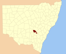
Forbes County is one of the 141 Cadastral divisions of New South Wales.

Map all coordinates using: OpenStreetMap 
Download coordinates as: KML
Forbes
New South Wales
Location in New South Wales
Lands administrative divisions around Forbes:
Cunningham Ashburnham Bathurst
Gipps Forbes Bathurst
Bland Monteagle King

Forbes County was named in honour of Chief Justice Sir Francis Forbes (1784-1841).[1] It is located south of the Lachlan River near Forbes, down to Grenfell. It includes the area along the Lachlan east to Cowra and the Boorowa River, and also south to Koorawatha

The Lachlan River at Cowra; the river is the boundary between Forbes and Bathurst

Parishes within this county


A full list of parishes found within this county; their current LGA and mapping coordinates to the approximate centre of each location is as follows:

ParishLGACoordinates
BandonForbes Shire33°31′54″S 148°15′04″E
Bang BangCowra Shire34°01′54″S 148°38′04″E
BindaWeddin Shire33°38′54″S 148°23′04″E
BiranganWeddin Shire33°42′54″S 148°07′04″E
BogolongWeddin Shire33°48′54″S 148°05′04″E
BoydForbes Shire33°54′54″S 147°36′04″E
BraulinForbes Shire33°30′54″S 148°01′04″E
BroulaCowra Shire33°50′54″S 148°33′04″E
BundaburrahForbes Shire33°30′54″S 147°53′04″E
ConimblaCowra Shire33°46′54″S 148°31′04″E
CudgelongCowra Shire33°54′54″S 148°46′04″E
CumbijowaForbes Shire33°25′54″S 148°08′04″E
CurrowongForbes Shire33°40′54″S 147°50′04″E
ErasaForbes Shire33°15′54″S 148°12′04″E
EualdrieWeddin Shire33°53′54″S 148°03′04″E
GooloogongCowra Shire33°39′54″S 148°31′04″E
GoonigalForbes Shire33°37′54″S 148°17′04″E
JemalongForbes Shire33°26′54″S 147°48′04″E
KangaroobyWeddin Shire33°42′54″S 148°20′04″E
MaudryForbes Shire33°41′54″S 148°03′04″E
MelyraWeddin Shire33°48′54″S 148°11′04″E
MerriganowryCowra Shire33°44′54″S 148°32′04″E
MoronglaCowra Shire33°53′54″S 148°39′04″E
MulyanCowra Shire33°48′54″S 148°35′04″E
MulyandryForbes Shire33°31′54″S 148°07′04″E
NanimaForbes Shire33°31′54″S 148°20′04″E
NeilaCowra Shire34°01′54″S 148°43′04″E
OomaForbes Shire33°38′54″S 148°09′04″E
TallabungForbes Shire33°33′54″S 147°49′04″E
ThurungleForbes Shire33°35′54″S 148°02′04″E
WaayourigongForbes Shire33°25′54″S 147°54′04″E
Wallah WallahWeddin Shire33°44′54″S 148°15′04″E
WarraderryWeddin Shire33°41′54″S 148°13′04″E
WarrangongCowra Shire33°59′54″S 148°30′04″E
WarrumbaCowra Shire33°48′54″S 148°22′04″E
WattamondaraCowra Shire33°54′54″S 148°37′04″E
WheogaWeddin Shire33°45′54″S 147°56′04″E
WongajongForbes Shire33°25′54″S 148°02′04″E

References


  1. "Forbes County". Geographical Names Register (GNR) of NSW. Geographical Names Board of New South Wales.


Текст в блоке "Читать" взят с сайта "Википедия" и доступен по лицензии Creative Commons Attribution-ShareAlike; в отдельных случаях могут действовать дополнительные условия.

Другой контент может иметь иную лицензию. Перед использованием материалов сайта WikiSort.org внимательно изучите правила лицензирования конкретных элементов наполнения сайта.

2019-2025
WikiSort.org - проект по пересортировке и дополнению контента Википедии