world.wikisort.org - Australia
Emu Flat is a locality in the Shire of Mitchell local government area, in Victoria, Australia. It is situated between Lancefield and Tooborac, 92 kilometres to the north-west of Melbourne by road.[2][3]
| Emu Flat Victoria | |
|---|---|
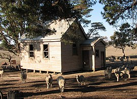
 Former Emu Flat State School | |
 Emu Flat | |
| Coordinates | 37°05′S 144°45′E |
| Postcode(s) | 3522.[1] |
| Location |
|
| LGA(s) | Shire of Mitchell |
Emu Flat has two "heritage places" listed in the Shire of Mitchell Planning Scheme. These are the Uniting Church (formerly Presbyterian Church), and the former State School.[4]
The Emu Flat Post Office opened on 17 September 1877 and closed in 1945.[5]
References
- "Location:Emu Flat, Vic". Postcode Search. Australia Post. Retrieved 21 April 2008.
- "travelmate.com.au". Archived from the original on 24 March 2007. Retrieved 21 April 2008.(Emu Flat-Baynton Rd, Nulla Vale )[dead link]
- "Emu Flat". Place Names Search. Geoscience Australia. Archived from the original on 5 June 2011. Retrieved 21 April 2008.
- "Schedule to the Heritage Overlay". Mitchell Planning Scheme. Archived from the original on 11 August 2008. Retrieved 21 April 2008.
- Phoenix Auctions History. "Post Office List". Retrieved 24 March 2021.
External links
![]() Media related to Emu Flat, Victoria at Wikimedia Commons
Media related to Emu Flat, Victoria at Wikimedia Commons
Текст в блоке "Читать" взят с сайта "Википедия" и доступен по лицензии Creative Commons Attribution-ShareAlike; в отдельных случаях могут действовать дополнительные условия.
Другой контент может иметь иную лицензию. Перед использованием материалов сайта WikiSort.org внимательно изучите правила лицензирования конкретных элементов наполнения сайта.
Другой контент может иметь иную лицензию. Перед использованием материалов сайта WikiSort.org внимательно изучите правила лицензирования конкретных элементов наполнения сайта.
2019-2025
WikiSort.org - проект по пересортировке и дополнению контента Википедии
WikiSort.org - проект по пересортировке и дополнению контента Википедии