world.wikisort.org - Australia
Denison County is one of the 141 Cadastral divisions of New South Wales. It contains the towns of Barooga and Berrigan.
| Denison New South Wales | |||||||||||||||
|---|---|---|---|---|---|---|---|---|---|---|---|---|---|---|---|
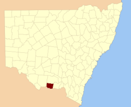 Location in New South Wales | |||||||||||||||
| |||||||||||||||
Denison County was named in honour of the Governor-General of New South Wales, Sir William Thomas Denison (1804-1871).[1]
Parishes within this county
![Denison County NSW as shown on John Sands 1886 map)[2]](http://upload.wikimedia.org/wikipedia/commons/thumb/0/0f/Denison_County_NSW_John_Sands_Map_%28B%26W%29.png/220px-Denison_County_NSW_John_Sands_Map_%28B%26W%29.png)
A full list of parishes found within this county; their current LGA and mapping coordinates to the approximate centre of each location is as follows:
| Parish | LGA | Coordinates |
|---|---|---|
| Barooga | Berrigan Shire Council | 35°49′54″S 145°40′04″E |
| Berrigan | Berrigan Shire Council | 35°33′54″S 145°44′04″E |
| Boomanoomana | Berrigan Shire Council | 35°54′54″S 145°54′04″E |
| Bull Plain | Federation Council | 35°44′54″S 146°10′04″E |
| Carlyle | Berrigan Shire Council | 35°49′54″S 145°54′04″E |
| Coreen West | Federation Council | 35°38′54″S 146°14′04″E |
| Cottadidda | Berrigan Shire Council | 35°54′54″S 145°45′04″E |
| Denison | Federation Council | 35°47′54″S 146°09′04″E |
| Dry Forest | Federation Council | 30°52′54″S 146°10′04″E |
| Finley | Berrigan Shire Council | 35°38′54″S 145°36′04″E |
| Gereldery | Berrigan Shire Council | 35°41′54″S 145°49′04″E |
| Headford | Berrigan Shire Council | 35°44′54″S 145°42′04″E |
| Kilnyana | Berrigan Shire Council | 35°45′54″S 145°55′04″E |
| Lalalty | Berrigan Shire Council | 35°50′54″S 145°46′04″E |
| Langunya | Berrigan Shire Council | 35°43′54″S 145°36′04″E |
| Momolong | Federation Council | 35°35′54″S 146°00′04″E |
| Mulwala | Federation Council | 35°55′54″S 146°01′04″E |
| Nangunia | Berrigan Shire Council | 35°45′54″S 145°48′04″E |
| Narrow Plains | Federation Council | 35°37′54″S 146°04′04″E |
| Osborne | Berrigan Shire Council | 35°36′54″S 145°50′04″E |
| Sargood | Berrigan Shire Council | 35°32′54″S 145°38′04″E |
| Savernake | Federation Council | 35°45′54″S 146°01′04″E |
| Tocumwal | Berrigan Shire Council | 35°46′54″S 145°33′04″E |
| Tongaboo | Berrigan Shire Council | 35°32′54″S 145°34′04″E |
| Turramia | Federation Council | 35°56′54″S 146°07′04″E |
| Ulupna | Berrigan Shire Council | 35°37′54″S 145°33′04″E |
| Wahgunyah | Federation Council | 35°50′54″S 146°02′04″E |
| Wangamong | Federation Council | 35°37′54″S 146°08′04″E |
| Warmatta | Berrigan Shire Council | 35°41′54″S 145°55′04″E |
| Warragubogra | Berrigan Shire Council | 35°38′54″S 145°42′04″E |
| Woperana | Berrigan Shire Council | 35°41′54″S 145°30′04″E |
References
- "Denison". Geographical Names Register (GNR) of NSW. Geographical Names Board of New South Wales. Retrieved 4 August 2013.
- The New atlas of Australia (John Sands 1886) map 21.
Текст в блоке "Читать" взят с сайта "Википедия" и доступен по лицензии Creative Commons Attribution-ShareAlike; в отдельных случаях могут действовать дополнительные условия.
Другой контент может иметь иную лицензию. Перед использованием материалов сайта WikiSort.org внимательно изучите правила лицензирования конкретных элементов наполнения сайта.
Другой контент может иметь иную лицензию. Перед использованием материалов сайта WikiSort.org внимательно изучите правила лицензирования конкретных элементов наполнения сайта.
2019-2026
WikiSort.org - проект по пересортировке и дополнению контента Википедии
WikiSort.org - проект по пересортировке и дополнению контента Википедии