world.wikisort.org - Armenia
Tegher (Armenian: Տեղեր, also Romanized as Tekher, Dgyr or Dgher; meaning "medicine") is a village in the Aragatsotn Province of Armenia on the southern slope of Mount Aragats. It earns its name from the large assortment of healing herbs that are found in the surrounding vicinity.
Tegher
Տեղեր | |
|---|---|
 Tegher Monastery | |
 Tegher | |
| Coordinates: 40°20′43″N 44°14′11″E | |
| Country | Armenia |
| Marz (Province) | Aragatsotn |
| Elevation | 1,710 m (5,610 ft) |
| Population (2004) | |
| • Total | 261 |
| Time zone | UTC+4 ( ) |
| • Summer (DST) | UTC+5 ( ) |
The town contains the Monastery of Tegher built in 1213. The ruins of the 9th century village of Tegher (Old Tegher) sit a short distance walk from the monastery. Numerous foundations may be seen, along with the remains of a Tukh Manuk funerary chapel of the 5th century. Nearby is also a medieval to 19th century cemetery with some mausoleums and khachkars.
Nearby is also a large radio telescope as well as an unfinished solar power plant, both from the Soviet era.
Gallery
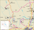 Road map of Tegher and the surrounding region.
 Tegher Monastery
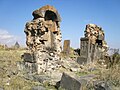 5th century Tukh Manuk Chapel ruins near the monastic complex.
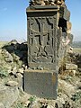 Khachkar at the chapel.


Population
| Year | 1831 | 1873 | 1897 | 1922 | 1926 | 1931 | 1939 | 1959 | 2001 | 2004 |
|---|---|---|---|---|---|---|---|---|---|---|
| Population | 35 | 364 | 459 | 506 | 408 | 367 | 655 | 554 | 90 | 261 |
Nearby sites
Towns
- Ashtarak
- Oshakan
Villages
- Byurakan
- Agarak
- Aghtsk
- Parpi
Historical sites
- Amberd fortress
See also
- Aragatsotn Province
References
- Tegher, Armenia at GEOnet Names Server
- Report of the results of the 2001 Armenian Census
- Kiesling, Rediscovering Armenia, p. 17, available online at the US embassy to Armenia's website
External links
Capital: Ashtarak | ||
| Urban communities |
|  |
| Rural communities |
| |
| Non-community settlements |
| |
| Former settlements | ||
На других языках
- [en] Tegher, Armenia
[ru] Тегер (село)
Теге́р (арм. Տեղեր - «Места») — село в Арагацотнской области Армении, происхождение названия связано со словом «тег» - «место».Другой контент может иметь иную лицензию. Перед использованием материалов сайта WikiSort.org внимательно изучите правила лицензирования конкретных элементов наполнения сайта.
WikiSort.org - проект по пересортировке и дополнению контента Википедии