world.wikisort.org - Algeria
Tademaït is a natural region in the Sahara Desert right in the centre of Algeria. It is located north of In Salah and south of the Grand Erg Occidental in the Adrar District of Adrar Province, El Ménia District of Ghardaïa Province and the northern end of Tamanrasset Province. It is one of the places of the Sahara Desert where the summer heat is most extreme.
Tademaït | |
|---|---|
Natural region | |
 Landscape of the Tademaït region | |
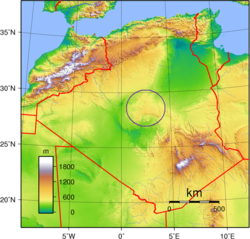 Location of the Tademaït Plateau in Algeria. | |
| Country | Algeria |
| Elevation | 600 m (2,000 ft) |
Geography
The Tademaït is a rocky plateau made up of cretaceous terrain with a general slope towards the northeast. It is an extremely dry and hyper-arid area with a hot desert climate (Köppen climate classification BWh) as the region is virtually rainless throughout the year and it has long, extremely hot summers and short, very warm winters .[1]
A meteorite was found in Tademaït in November 2002.[2]
See also
- Geography of Algeria
- Tuat
References
- "Tademaït". www.cosmovisions.com. Retrieved 2019-09-07.
- "Meteoritical Bulletin: Entry for Plateau du Tademait 005". www.lpi.usra.edu. Retrieved 2019-09-07.
External links
- Tademait Plateau: A regional groundwater recharge area in the centre of the Algerian Sahara
This article about a location in Adrar Province is a stub. You can help Wikipedia by expanding it. |
На других языках
[de] Tademait-Plateau
Das Tademait-Plateau (französisch: Plateau du Tademaït, „Garten des Satans“) ist eine Hochebene (Geländeform, T-hypsographisch) in der Provinz In Salah, Algerien.[1]- [en] Tademaït
[it] Tademaït
L'altopiano del Tademaït (in francese: Plateau du Tademaït, «Giardino di Satana») è un altopiano situato nella provincia di Tamanrasset, in Algeria[1].Другой контент может иметь иную лицензию. Перед использованием материалов сайта WikiSort.org внимательно изучите правила лицензирования конкретных элементов наполнения сайта.
WikiSort.org - проект по пересортировке и дополнению контента Википедии