world.wikisort.org - Algeria
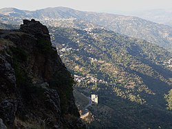
Iferhounene (French:Iferhounène)(Arabic:ايفرحونن)(TifinaƔ:ⵉⴼⴻⵔⵀⵓⵏⴻⵏ) is a town and commune in Tizi Ouzou Province in northern Algeria.[1] It's known to be close to the city of Ain El Hammam and is traversed through daily by Tizi Ouzou commuters. It is also known for it's snowy climate during the winter[2]
Iferhounène
Iferhunen Iferhounene | |
|---|---|
Commune and town | |
 | |
 | |
 Iferhounène | |
| Coordinates: | |
| Country | |
| Province | Tizi Ouzou Province |
| Elevation | 3,600 ft (1,100 m) |
| Time zone | UTC+1 (CET) |
It has grown exponentially over the 21st century in terms of modernization, however it's surrounding villages have suffered greatly from this development because of people moving in Iferhounene for improvements in transportation and basic commodities. Therefore reducing the village populations and causing the death of some villages like Ait Hammou.
References
- "MICHELIN Iferhounene map - ViaMichelin". www.viamichelin.com. Retrieved 2022-06-30.
- Rédaction, La (2016-01-16). "Iferhounène sous la neige..." La Dépêche de Kabylie (in French). Retrieved 2022-06-30.
Текст в блоке "Читать" взят с сайта "Википедия" и доступен по лицензии Creative Commons Attribution-ShareAlike; в отдельных случаях могут действовать дополнительные условия.
Другой контент может иметь иную лицензию. Перед использованием материалов сайта WikiSort.org внимательно изучите правила лицензирования конкретных элементов наполнения сайта.
Другой контент может иметь иную лицензию. Перед использованием материалов сайта WikiSort.org внимательно изучите правила лицензирования конкретных элементов наполнения сайта.
2019-2025
WikiSort.org - проект по пересортировке и дополнению контента Википедии
WikiSort.org - проект по пересортировке и дополнению контента Википедии
