world.wikisort.org - Afghanistan
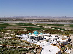
The town of Arghandab is the center of Arghandab District in Kandahar Province, Afghanistan, in the valley of Arghandab River northwest from Kandahar.[1] It is located on 31.6547°N 65.6494°E at an elevation of 1,112 metres (3,648 ft).[2]
Arghandab | |
|---|---|
 | |
 Arghandab Location in Afghanistan | |
| Coordinates: 31°39′17″N 65°38′58″E | |
| Country | |
| Province | Kandahar Province |
| District | Arghandab District |
| Occupation | |
| Elevation | 3,648 ft (1,112 m) |
| Time zone | + 4.30 |
References
- "Arghandab District, Kandahar, Afghanistan". www.mindat.org. Retrieved 2019-03-26.
- Al Jazeera English (2010-07-28), Fierce fighting in Afghanistan's Arghandab Valley, archived from the original on 2021-12-15, retrieved 2019-03-26
Текст в блоке "Читать" взят с сайта "Википедия" и доступен по лицензии Creative Commons Attribution-ShareAlike; в отдельных случаях могут действовать дополнительные условия.
Другой контент может иметь иную лицензию. Перед использованием материалов сайта WikiSort.org внимательно изучите правила лицензирования конкретных элементов наполнения сайта.
Другой контент может иметь иную лицензию. Перед использованием материалов сайта WikiSort.org внимательно изучите правила лицензирования конкретных элементов наполнения сайта.
2019-2025
WikiSort.org - проект по пересортировке и дополнению контента Википедии
WikiSort.org - проект по пересортировке и дополнению контента Википедии
