world.wikisort.org - Etats-Unis
Le comté de Rappahannock est un comté de Virginie, aux États-Unis.
| Comté de Rappahannock | |

| |
| Administration | |
|---|---|
| Pays | |
| État | |
| Chef-lieu | Washington |
| Fondation | 1833 |
| Démographie | |
| Population | 7 373 hab. (2010) |
| Densité | 11 hab./km2 |
| Géographie | |
| Coordonnées | 38° 41′ nord, 78° 10′ ouest |
| Superficie | 69 200 ha = 692 km2 |
| Superficie eau | 0 ha = 0 km2 |
| Superficie totale | 69 200 ha = 692 km2 |
| Localisation | |
 Localisation du comté dans l'État. | |
| Liens | |
| Site web | rappahannockcountyva.gov |
| modifier |
|
Un premier comté de Rappahannock a été créé en 1656 par détachement du comté de Lancaster, mais a disparu en 1692 pour former les comtés d'Essex et de Richmond.
L'actuel comté a été créé par une loi de l'Assemblée générale de Virginie en 1833 pour répondre aux besoins croissant de la population d'avoir un meilleur accès au siège du comté. Le territoire a été détaché du comté de Culpeper. Le comté a pris le nom de la rivière Rappahannock qui le sépare du comté de Fauquier.
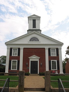
Le siège du comté est situé à Washington.
Situation dans l'État
| Historique des recensements | |||
| Ann. | Pop. | %± | |
|---|---|---|---|
| 1840 | 9 257 | — | |
| 1850 | 9 782 | ▲ +5,67 % | |
| 1860 | 8 850 | ▼ −9,53 % | |
| 1870 | 8 261 | ▼ −6,66 % | |
| 1880 | 9 291 | ▲ +12,47 % | |
| 1890 | 8 678 | ▼ −6,6 % | |
| 1900 | 8 843 | ▲ +1,9 % | |
| 1910 | 8 044 | ▼ −9,04 % | |
| 1920 | 8 070 | ▲ +0,32 % | |
| 1930 | 7 717 | ▼ −4,37 % | |
| 1940 | 7 208 | ▼ −6,6 % | |
| 1950 | 6 112 | ▼ −15,21 % | |
| 1960 | 5 368 | ▼ −12,17 % | |
| 1970 | 5 199 | ▼ −3,15 % | |
| 1980 | 6 093 | ▲ +17,2 % | |
| 1990 | 6 622 | ▲ +8,68 % | |
| 2000 | 6 983 | ▲ +5,45 % | |
| 2010 | 7 373 | ▲ +5,58 % | |
Le comté occupe une superficie de 690 km2 dans la pointe Nord de la Virginie. Il est limité respectivement par:
- le Comté de Warren au nord-ouest
- le comté de Fauquier au nord-est
- le comté de Culpeper au sud-est
- le Comté de Madison au sud-ouest
- le comté de Page à l'ouest
Une grande partie du territoire ouest du comté est occupée par les montagnes bleues.
- Intersection de la Skyline Drive avec l'U.S. Route 211 à Thornton Gap, à la frontière entre le comté de Rappahannock et celui de Page.
Démographie
La population augmente de nouveau depuis les années 1970 du fait de la pression exercée par l'extension des quartiers sud de Washington, la capitale fédérale.
La densité a atteint 10 hab./km2 en 2010. Le territoire reste donc essentiellement rural. Il est occupé à 93 % par une population d'Euro-Américains avec une minorité de 5,5 % d'Afro-Américains.
Liens internes
- Comtés du Commonwealth de Virginie
Liens externes
- site officiel
- Ressource relative à la géographie :
- Portail de la Virginie
На других языках
[de] Rappahannock County
Rappahannock County[1] ist ein County im Bundesstaat Virginia der Vereinigten Staaten. Im Jahr 2020 hatte das County 7348 Einwohner und eine Bevölkerungsdichte von 10,6 Einwohnern pro Quadratkilometer. Der Verwaltungssitz (County Seat) ist Washington.[en] Rappahannock County, Virginia
Rappahannock County is a county located in the northern Piedmont region of the Commonwealth of Virginia, US, adjacent to Shenandoah National Park. As of the 2020 Census, the population was 7,348.[1] Its county seat is Washington. The name "Rappahannock" comes from the Algonquian word lappihanne (also noted as toppehannock), meaning "river of quick, rising water" or "where the tide ebbs and flows." The county is included in the Washington-Arlington-Alexandria, DC-VA-MD-WV Metropolitan Statistical Area.- [fr] Comté de Rappahannock
[ru] Раппаханнок (округ)
Округ Раппаханнок (англ. Rappahannock County) располагается в США, в штате Виргиния. По состоянию на 2010 год, численность населения составляет 7373 человек. Был образован в 1833 году, получил своё название по наименованию реки Раппаханнок. Административный центр — городок Вашингтон[en].Другой контент может иметь иную лицензию. Перед использованием материалов сайта WikiSort.org внимательно изучите правила лицензирования конкретных элементов наполнения сайта.
WikiSort.org - проект по пересортировке и дополнению контента Википедии
