world.wikisort.org - Regno_Unito
Vale of White Horse è un distretto dell'Oxfordshire, Inghilterra, Regno Unito, con sede ad Abingdon.
|
Questa voce o sezione sull'argomento autorità unitarie dell'Inghilterra non cita le fonti necessarie o quelle presenti sono insufficienti.
|
| Distretto di Vale of White Horse Distretto | |
|---|---|
 | |
| Localizzazione | |
| Stato | |
| Regione | Est |
| Contea | |
| Amministrazione | |
| Capoluogo | Abingdon |
| Esecutivo | Liberal Democratico |
| Territorio | |
| Coordinate del capoluogo | 51°40′N 1°17′W |
| Superficie | 578,63 km² |
| Abitanti | 117 000 |
| Densità | 202,2 ab./km² |
| Altre informazioni | |
| Fuso orario | UTC+0 |
| Codice ONS | 38UE |
| Rappresentanza parlamentare | Collegio di Oxford West and Abingdon, di Wantage |
| Cartografia | |
 Abingdon | |
 | |
| Sito istituzionale | |
Il distretto fu creato con il Local Government Act 1972, il 1º aprile 1974 dalla fusione del municipal borough di Abingdon con il distretto urbano di Wantage, il distretto rurale di Abingdon, il distretto rurale di Faringdon e parte del distretto rurale di Wantage nel Berkshire.
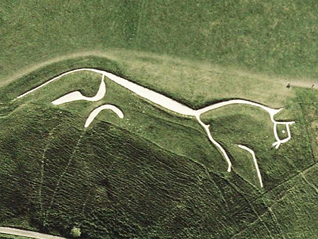
La valle prende il nome dal Cavallo Bianco di Uffington, un geoglifo di epoca preistorica tracciato sul pendio di un rilievo collinare in gesso, rappresenta una figura animale stilizzata.
Parrocchie civili
- Abingdon
- Appleford-on-Thames
- Appleton-with-Eaton
- Ardington
- Ashbury
- Baulking
- Besselsleigh
- Blewbury
- Bourton
- Buckland
- Buscot
- Charney Bassett
- Childrey
- Chilton
- Coleshill
- Compton Beauchamp
- Cumnor
- Denchworth
- Drayton
- East Challow
- East Hanney
- East Hendred
- Eaton Hastings
- Fernham
- Frilford
- Fyfield and Tubney
- Garford
- Goosey
- Great Coxwell
- Great Faringdon
- Grove
- Harwell
- Hatford
- Hinton Waldrist
- Kennington (Oxfordshire)
- Kingston Bagpuize with Southmoor
- Kingston Lisle
- Letcombe Bassett
- Letcombe Regis
- Little Coxwell
- Littleworth
- Lockinge
- Longcot
- Longworth
- Lyford
- Marcham
- Milton
- North Hinksey
- Pusey
- Radley
- St. Helen Without
- Shellingford
- Shrivenham
- South Hinksey
- Sparsholt
- Stanford in the Vale
- Steventon
- Sunningwell
- Sutton Courtenay
- Uffington
- Upton
- Wantage
- Watchfield
- West Challow
- West Hanney
- West Hendred
- Woolstone
- Wootton
- Wytham
Collegamenti esterni
- Sito ufficiale, su whitehorsedc.gov.uk.
- (EN) Vale of White Horse, su Enciclopedia Britannica, Encyclopædia Britannica, Inc.
| Controllo di autorità | VIAF (EN) 236071679 |
|---|
На других языках
[de] Vale of White Horse
Vale of White Horse („Tal des weißen Pferdes“) ist ein District in der Grafschaft Oxfordshire in England und nach dem Scharrbild Uffington White Horse benannt. Verwaltungssitz ist Abingdon; weitere bedeutende Orte sind Grove, Faringdon und Wantage.[en] Vale of White Horse
The Vale of White Horse is a local government district of Oxfordshire in England. It was historically a north-west projection of Berkshire. The area is commonly referred to as the 'Vale of the White Horse'. It is crossed by the Ridgeway National Trail in its far south, across the North Wessex Downs AONB at the junction of four counties. The northern boundary is defined by the River Thames. The name refers to Uffington White Horse, a prehistoric hill figure.- [it] Vale of White Horse
[ru] Вейл-оф-Уайт-Хорс
Вейл-оф-Уайт-Хорс (англ. Vale of White Horse) — неметрополитенский район (англ. non-metropolitan district) в графстве Оксфордшир (Англия). Административный центр — город Абингдон.Текст в блоке "Читать" взят с сайта "Википедия" и доступен по лицензии Creative Commons Attribution-ShareAlike; в отдельных случаях могут действовать дополнительные условия.
Другой контент может иметь иную лицензию. Перед использованием материалов сайта WikiSort.org внимательно изучите правила лицензирования конкретных элементов наполнения сайта.
Другой контент может иметь иную лицензию. Перед использованием материалов сайта WikiSort.org внимательно изучите правила лицензирования конкретных элементов наполнения сайта.
2019-2025
WikiSort.org - проект по пересортировке и дополнению контента Википедии
WikiSort.org - проект по пересортировке и дополнению контента Википедии