world.wikisort.org - Russia
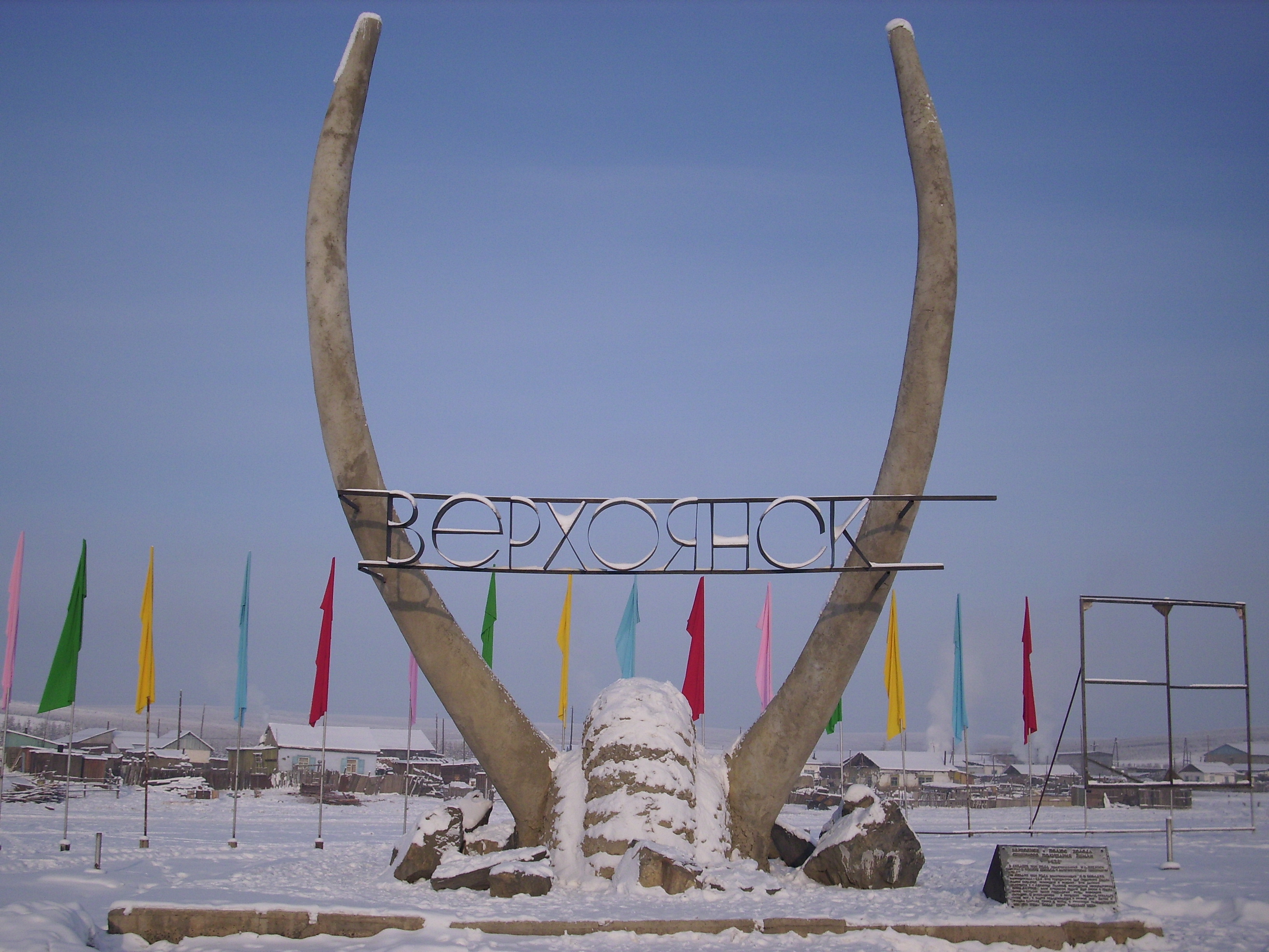
Verchojansk (in russo: Верхоянск?, trascritto anche Verhojansk, Verkhojansk, Verkhoyansk; in jakuto: Үөһээ Дьааҥы, Uöhee D'aangyo) è una città della Russia, situata nella Siberia orientale, nella Repubblica autonoma della Sacha-Jacuzia sul medio corso del fiume Jana.
| Verchojansk località abitata | |
|---|---|
| Верхоянск | |
  | |
 | |
| Localizzazione | |
| Stato | |
| Circondario federale | Estremo Oriente |
| Soggetto federale | |
| Rajon | Verchojansk |
| Territorio | |
| Coordinate | 67°33′N 133°23′E |
| Altitudine | 140 m s.l.m. |
| Superficie | 35 km² |
| Abitanti | 1 131 (2017) |
| Densità | 32,31 ab./km² |
| Altre informazioni | |
| Cod. postale | 678530 |
| Prefisso | 41165 |
| Fuso orario | UTC+10 |
| Cartografia | |
 Verchojansk | |
Storia
Risale al 1638 un accampamento invernale cosacco, fondato una novantina di chilometri a sudovest dell'abitato moderno; lo status di città arrivò nel 1817.
Popolazione
Fonte: mojgorod.ru
| 1897 | 1939 | 1959 | 1970 | 1979 | 1989 | 2002 | 2007 | 2015 |
|---|---|---|---|---|---|---|---|---|
| 1 007 | 1 614 | 1 432 | 1 897 | 1 716 | 1 923 | 1 286 | 1 300 | 1 150 |
Geografia fisica
 |
Territorio
Clima
Nella zona di Verchojansk si registra il clima invernale più rigido dell'emisfero nord del mondo abitato, a causa della formazione di poderose strutture altopressorie termiche (anticicloniche, anche oltre i 1040 hPa per settimane) che causano un accumulo, nei più bassi strati atmosferici, di aria più pesante già freddissima poiché proveniente dall'atmosfera più elevata, che a sua volta si raffredda progressivamente anche a causa della irrisoria, se non inesistente, insolazione, specialmente nel culmine dell'inverno attorno al periodo natalizio. Sono quindi molto frequenti delle forti inversioni termiche. Ovviamente la notevole continentalità del luogo (lontananza dal mare) acuisce non poco l'estrema intensità del gelo.
Verchojansk, in particolare, è famosa per essere uno dei centri abitati più freddi di tutto il mondo[1], primato conteso con Ojmjakon e Tomtor. La città ha raggiunto una temperatura minima assoluta di −67,6 °C; alcune fonti riportano invece un valore minimo di −69,8 °C, registrato nel febbraio 1892.[2]. Nella zona le escursioni annue possono raggiungere e superare i 100 °C dal momento che il massimo storico di temperatura, risalente al 20 giugno del 2020, è di 38 °C.[3] Questo dato, se confermato dalle massime autorità internazionali, avrebbe battuto il record per la temperatura più alta nella storia dell'Artico.[4]
| Verchojansk (1991-2020) Fonte:[5] | Mesi | Stagioni | Anno | ||||||||||||||
|---|---|---|---|---|---|---|---|---|---|---|---|---|---|---|---|---|---|
| Gen | Feb | Mar | Apr | Mag | Giu | Lug | Ago | Set | Ott | Nov | Dic | Inv | Pri | Est | Aut | ||
| T. max. media (°C) | −41,6 | −36,7 | −18,8 | −1,8 | 10,3 | 20,6 | 23,4 | 19,2 | 8,7 | −8,5 | −30,0 | −40,6 | −39,6 | −3,4 | 21,1 | −9,9 | −8,0 |
| T. media (°C) | −44,7 | −42,1 | −28,9 | −10,9 | 4,2 | 13,9 | 16,5 | 12,1 | 2,8 | −13,4 | −33,7 | −43,6 | −43,5 | −11,9 | 14,2 | −14,8 | −14,0 |
| T. min. media (°C) | −47,7 | −46,3 | −37,4 | −20,4 | −2,0 | 7,3 | 10,0 | 5,7 | −1,9 | −18,0 | −37,3 | −46,3 | −46,8 | −19,9 | 7,7 | −19,1 | −19,5 |
| T. max. assoluta (°C) | −9,5 (1997) | −0,3 (1940) | 5,6 (2017) | 14,3 (1943) | 28,1 (1981) | 38,0 (2020) | 37,3 (1988) | 33,7 (1969) | 25,1 (1934) | 14,5 (1949) | 1,1 (1975) | −5,3 (1979) | −0,3 | 28,1 | 38,0 | 25,1 | 38,0 |
| T. min. assoluta (°C) | −66,6 (1912) | −67,6 (1892) | −60,3 (1912) | −57,2 (1896) | −34,2 (1890) | −7,9 (1982) | −3,2 (1964) | −9,9 (1962) | −21,7 (1957) | −48,7 (1915) | −57,2 (1960) | −64,5 (1902) | −67,6 | −60,3 | −9,9 | −57,2 | −67,6 |
| Nuvolosità (okta al giorno) | 5,0 | 4,8 | 4,3 | 5,0 | 6,5 | 6,4 | 6,3 | 6,6 | 7,1 | 6,7 | 5,8 | 5,0 | 4,9 | 5,3 | 6,4 | 6,5 | 5,8 |
| Precipitazioni (mm) | 6 | 5 | 5 | 4 | 16 | 30 | 34 | 30 | 22 | 13 | 11 | 6 | 17 | 25 | 94 | 46 | 182 |
| Giorni di pioggia | 0 | 0 | 0 | 1 | 8 | 14 | 14 | 14 | 10 | 0,4 | 0,0 | 0,0 | 0,0 | 9,0 | 42,0 | 10,4 | 61,4 |
| Nevicate (cm) | 20 | 22 | 24 | 18 | 1 | 0 | 0 | 0 | 0 | 5 | 12 | 16 | 58 | 43 | 0 | 17 | 118 |
| Giorni di neve | 17 | 16 | 12 | 9 | 8 | 1 | 0,3 | 0,4 | 8,0 | 17,0 | 18,0 | 16,0 | 49,0 | 29,0 | 1,7 | 43,0 | 122,7 |
| Giorni di nebbia | 1 | 0,3 | 0,2 | 0,1 | 0,03 | 0,1 | 1,0 | 5,0 | 5,0 | 1,0 | 0,1 | 1,0 | 2,3 | 0,3 | 6,1 | 6,1 | 14,8 |
| Umidità relativa media (%) | 74 | 74 | 69 | 63 | 58 | 57 | 61 | 69 | 74 | 78 | 77 | 75 | 74,3 | 63,3 | 62,3 | 76,3 | 69,1 |
| Vento (direzione-m/s) | SW 0,6 | SW 0,5 | SW 0,7 | NE 1,5 | NE 2,4 | N 2,6 | N 2,2 | NE 1,7 | SW 1,6 | SW 1,1 | SW 0,7 | SW 0,7 | 0,6 | 1,5 | 2,2 | 1,1 | 1,4 |
Note
- Classifica delle Città più fredde del mondo Travel365.it
- http://pogoda.ru.net/climate/24266.htm
- https://twitter.com/WorldClimateSvc/status/1274324717650968579
- https://www.internazionale.it/notizie/gabriele-crescente/2020/06/22/artico-record-temperatura
- (RU) Климатические таблицы. Данные для Верхоянска.
Altri progetti
 Wikimedia Commons contiene immagini o altri file su Verchojansk
Collegamenti esterni
- (EN) Verchojansk, su Enciclopedia Britannica, Encyclopædia Britannica, Inc.
- Sito ufficiale del censimento 2002, su perepis2002.ru.
- Mojgorod.ru.
- WorldClimate.com.
| Controllo di autorità | VIAF (EN) 246210761 · LCCN (EN) n91028854 · J9U (EN, HE) 987007567667305171 · WorldCat Identities (EN) lccn-n91028854 |
|---|
На других языках
[de] Werchojansk
Werchojansk (russisch Верхоя́нск, jakutisch Үөһээ Дьааҥы/Uöhee D'aangy) ist eine Kleinstadt in der Republik Sacha im Fernen Osten Russlands.[2] Mit 1311 Einwohnern (Stand 14. Oktober 2010)[1] gehört sie zu den kleinsten Ortschaften mit Stadtstatus in ganz Russland. Sie liegt im gleichnamigen Ulus Werchojansk, ist aber nicht dessen Kreissitz (das ist die etwa 50 Kilometer ostnordöstlich gelegene Siedlung Batagai).[en] Verkhoyansk
Verkhoyansk (Russian: Верхоянск, IPA: [vʲɪrxɐˈjansk]; Yakut: Верхоянскай, Verkhoyanskay) is a town in Verkhoyansky District of the Sakha Republic, Russia, located on the Yana River in the Arctic Circle, 92 kilometers (57 mi) from Batagay, the administrative center of the district, and 675 kilometers (419 mi) north of Yakutsk, the capital of the Sakha republic. As of the 2010 Census, its population was 1,311.[3] Verkhoyansk holds the record for the hottest temperature ever recorded north of the Arctic Circle, with 38.0 °C (100.4 °F), and it also holds the record for the coldest temperature ever recorded in Asia, −67.8 °C (−90.0 °F). The cold record is shared with Oymyakon.[fr] Verkhoïansk
Verkhoïansk (en russe : Верхоянск, en iakoute : Үөһээ Дьааҥы) est une petite ville de la République de Sakha (Iakoutie), en Russie. Sa population s'élevait à 1 212 habitants en 2013. On y trouve notamment un port, un aéroport, un dépôt de fourrures, et un centre d'élevage de rennes. C'est un pôle du froid, et l'un des lieux les plus froids de la Terre.- [it] Verchojansk
[ru] Верхоянск
Верхоя́нск (якут. Верхоянскай) — город в Верхоянском улусе Якутии, на правом берегу реки Яна, в 92 км к юго-западу от административного центра улуса — Батагая. Самый северный город Якутии.Другой контент может иметь иную лицензию. Перед использованием материалов сайта WikiSort.org внимательно изучите правила лицензирования конкретных элементов наполнения сайта.
WikiSort.org - проект по пересортировке и дополнению контента Википедии