world.wikisort.org - Mexico
Ojinaga Municipality (formally: Manuel Ojinaga ) is one of the 67 municipalities of Chihuahua, in northern Mexico. The municipal seat lies at Ojinaga, a rural bordertown on the U.S.-Mexico border. The municipality has an area of 9,500.50 km2 (3,668.16 sq mi).
Ojinaga | |
|---|---|
Municipality | |
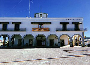
 Ojinaga government headquarters | |
| Nickname(s): La perla del desierto | |
 Municipality of Ojinaga in Chihuahua | |
 Ojinaga Location in Mexico | |
| Coordinates: 29°34′N 104°25′W | |
| Country | |
| State | Chihuahua |
| Municipal seat | Ojinaga |
| Area | |
| • Total | 9,500.5 km2 (3,668.2 sq mi) |
| Population (2010) | |
| • Total | 26,304 |
| • Density | 2.8/km2 (7.2/sq mi) |
Geography
Ojinaga, named after Juarista governor Manuel Ojinaga, reported a 2010 census population of 22,744 people in the town, which serves as municipal seat of the municipality of 26,304 inhabitants.[1] The municipality includes numerous very small outlying communities, the largest of which are El Oasis and Nueva Holanda.
Towns and villages
The municipality has 108 localities. The largest are:
| Name | 2010 Census Population[1] |
|---|---|
| Ojinaga | 22,744 |
| El Oasis | 475 |
| Nueva Holanda | 426 |
| La Esmeralda | 187 |
| Maijoma | 160 |
| Valverde | 143 |
| El Divisadero | 135 |
| El Mezquite | 120 |
| Potrero del Llano | 129 |
| Total Municipality | 26,304 |
Adjacent municipalities and counties
- Manuel Benavides Municipality – southeast
- Camargo Municipality – south
- Julimes Municipality – southwest
- Aldama Municipality – southwest
- Coyame del Sotol Municipality – west
- Guadalupe Municipality – northwest
- Presidio County, Texas – north and northeast
References
- "Ojinaga". Catálogo de Localidades. Secretaría de Desarrollo Social (SEDESOL). Retrieved 23 April 2014.
- 2010 census tables: INEGI: Instituto Nacional de Estadística, Geografía e Informática
- Chihuahua Enciclopedia de los Municipios de México
External links
- Ojinaga Hoy
- La Perla del Desierto, local website
- Camino Minerals, Maijoma mine, Ojinaga Municipality
На других языках
- [en] Ojinaga Municipality
[ru] Охинага (муниципалитет)
Охинага (исп. Ojinaga) — муниципалитет в Мексике, штат Чиуауа с административным центром в городе Мануэль-Охинага. Численность населения, по данным переписи 2010 года, составила 26 304 человека.Текст в блоке "Читать" взят с сайта "Википедия" и доступен по лицензии Creative Commons Attribution-ShareAlike; в отдельных случаях могут действовать дополнительные условия.
Другой контент может иметь иную лицензию. Перед использованием материалов сайта WikiSort.org внимательно изучите правила лицензирования конкретных элементов наполнения сайта.
Другой контент может иметь иную лицензию. Перед использованием материалов сайта WikiSort.org внимательно изучите правила лицензирования конкретных элементов наполнения сайта.
2019-2025
WikiSort.org - проект по пересортировке и дополнению контента Википедии
WikiSort.org - проект по пересортировке и дополнению контента Википедии
