world.wikisort.org - Germany
Staufenberg is a village in Baden-Württemberg, Germany. It is administratively part of the town of Gernsbach in the Rastatt district.
Staufenberg | |
|---|---|
Stadtteil of Gernsbach | |
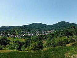
 View over Staufenberg | |
 Coat of arms | |
Location of Staufenberg  | |
 Staufenberg  Staufenberg | |
| Coordinates: 48°45′58″N 8°18′28″E | |
| Country | Germany |
| State | Baden-Württemberg |
| Admin. region | Karlsruhe |
| District | Rastatt |
| Town | Gernsbach |
| Area | |
| • Total | 4.0104 km2 (1.5484 sq mi) |
| Elevation | 226 m (741 ft) |
| Population | |
| • Total | 1,600 |
| • Density | 400/km2 (1,000/sq mi) |
| Time zone | UTC+01:00 (CET) |
| • Summer (DST) | UTC+02:00 (CEST) |
| Postal codes | 76593 |
| Dialling codes | 07224 |
Geography
The village is located directly west of Gernsbach on a small tributary of the Murg River.
History
The first documented mention of Staufenberg is as 'vinea Stoufenberg' in the year 1274.[2] On January 1, 1971, Staufenberg was incorporated into the town of Gernsbach.[3]
References
- "Staufenberg". gernsbach.de. Stadt Gernsbach. Retrieved 29 September 2022.
- "Staufenberg". gernsbach.de. Stadt Gernsbach. Retrieved 29 September 2022.
- Historisches Gemeindeverzeichnis für die Bundesrepublik Deutschland : Namens-, Grenz- und Schlüsselnummernänderungen bei Gemeinden, Kreisen und Regierungsbezirken vom 27.5.1970 bis 31.12.1982. Stuttgart: Kohlhammer. 1983. p. 483. ISBN 3170032631.
На других языках
[de] Staufenberg (Gernsbach)
Staufenberg ist ein Stadtteil von Gernsbach im Landkreis Rastatt in Baden-Württemberg.- [en] Staufenberg (Gernsbach)
Текст в блоке "Читать" взят с сайта "Википедия" и доступен по лицензии Creative Commons Attribution-ShareAlike; в отдельных случаях могут действовать дополнительные условия.
Другой контент может иметь иную лицензию. Перед использованием материалов сайта WikiSort.org внимательно изучите правила лицензирования конкретных элементов наполнения сайта.
Другой контент может иметь иную лицензию. Перед использованием материалов сайта WikiSort.org внимательно изучите правила лицензирования конкретных элементов наполнения сайта.
2019-2025
WikiSort.org - проект по пересортировке и дополнению контента Википедии
WikiSort.org - проект по пересортировке и дополнению контента Википедии